April 23, 2024

MyNature Animal Tracks MyNature Tree Guide MyNature Animal Tracks MyNature Fishing App

Woolly Bears and the Winter Weather

I’m sure you’ve heard the old wives tale about the Woolly Bear caterpillars ability to predict the winter weather. The wider the brown middle band is, the milder the winter. Well, since I didn’t have any immediate plans for the  weekend I decided I may as well startwoollybowl25 my own study and see just how accurate a Woolly Bear can be. Really I just love projects and this sounded kind of fun and it gave me an excuse to go outdoors. I grabbed an old cool whip container and the hunt was on. Finding Woolly Bears in the Fall really isn’t a tough task, the best places to look are around rocks, rock walls, flower gardens and sidewalks.  My goal was to collect 25 Woolly Bears and measure their mid sections as well as the black bands on their head and tail. If they were to predict a mild winter then the middle brown or sometimes orange/brown band would have to be at least half the body length. The average body length of a Woolly Bear in a relaxed resting position is 1 1/2 inches long. That means we would need to get an average length of 3/4 of an inch or more on the brown band on our collection. Lets see what our measurements added up to.

Average black head band length – 0.44 inches or about 7/16ths of  an inch.

Average black tail band length –  0.325 inches or about 5/16ths of an inch

Average brown middle band length – 0.645 inches or about 5/8ths of an inch

measure1
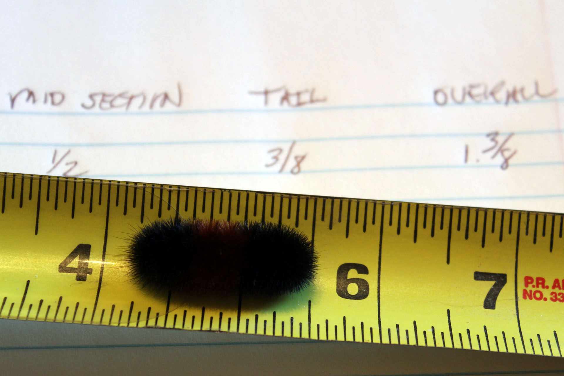
Judging by the figures above according to the Woolly Bear folklore we should be in for a harsh winter.    Damn! and here I was hoping for a mild one.  The interesting thing about those averages is that there were 8 specimens that measured 3/4 of an inch or more in length. Subjects #10 and #14 both measured a full inch long at the mid section, nearly twice as long as the majority of our caterpillars. Most of our caterpillars, 10 total, measured a solid 1/2 inch long at the mid section.


Not to get discouraged (after all I want a mild winter) I set out the next day to collect as many Woolly Bears as I could find in 30 minutes. This time I would count the brown segments and approach it from that angle. I managed to round up 28 caterpillars. Yes, some could have been the same ones as the day before but who could tell, they all look alike.  A Woolly Bears body has 13 distinct segments to it.  Technically we would need to find that 7 segments were brown to predict a mild winter, it wasn’t looking good.

Average black head segments – 4.678 2woollybears

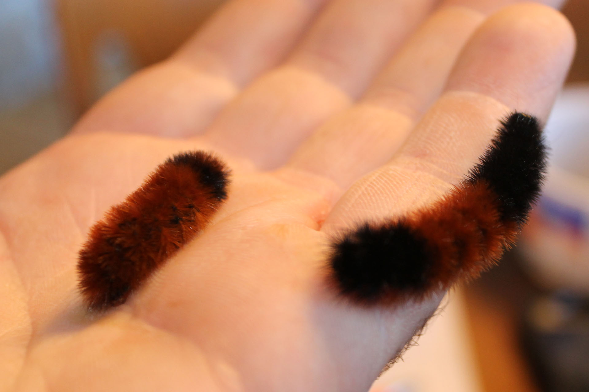
Average black tail segments – 3.25

Average brown segments – 5.035

I really shouldn’t have included specimen #17 because he had only 2 black head segments no black tail segment and a whopping 11 brown segments. If I hadn’t included him our average brown segments would have been closer to four.  Nearly half, 12 of our caterpillars had only 4 brown segments.  There were a total of eight subjects that had 6 brown body segments. All this again according to folklore points toward a hard winter.  (Insert sad face here.)

Some interesting things I learned with my little study:

  • Woolly Bears crap a lot and you’d be surprised at just how big a poop a little caterpillar can do.
  • No matter how hard you try you can’t get a Woolly Bear to uncurl with your finger.
  • You can however get a Woolly Bear to uncurl by placing in him in your cupped hand, cup over that hand with your other one and gently blow long breaths into your hands. Usually by four long breaths you’ll feel the caterpillar start to move. woollypoop
  • Woolly bears crap a lot. Did I say that already?

We’ve already got our calendar marked for next year to do another little study. We’ll find out shortly if the Woolly Bear is right and the winter of 2013-2014 is a harsh one and if they really can predict the winter weather.

Stay tuned!


 Update 1/30/2014

I chose that nice blue color to match the temperatures outside…… it is FREEZING!!  I don’t remember a colder winter than this one. We’ve had some significant snowfall early in the season and then a lot of freezing rain and a lot of below zero days. So the score on the first year of our study is 1 zip. The Woolly Bears have this winter correct, harsh no doubt.

Update 4/22/2014

Believe it or not the snow just melted, winters here in the Adirondacks seem to last forever. Those caterpillars sure had this winter pegged. It was long, it was cold, it was snowy!!


Waiting on the Wind

On the verge.
You can feel the excitement
you can see it in their color.
Pure white, the purest
the white of cotton, of goose down
of impending snows.
 
milkweedblogAs so much life ends
the flowers
the grasses
the falling leaves
theirs is but to begin 
their journey
 
Waiting on the wind
 
To carry them away
effortlessly, floating
suspended in a promise
 
 
A promise  to carry them
hold them
to set them free, to explore
to grow
where the soil is fertile and the soaking rains fall
 
The whitest of whites
a seed
a simple seed, yet I feel the excitement.
The wind stirs
the leaves rattle
a journey begins.


Page Jumps and Anchor Points Made Simple

There’s one thing for sure if your blogging and that’s that at some point in time your going to want to make use of page jumps or anchor points.  So what is a page jump or anchor point? Simply put it’s a link from one spot in your blog article to another spot in the same blog article. Page jumps eliminate the need to scroll through the whole article to find a certain subject your interested in reading. On my blog for example I usually keep a day to day journal when I go on a trip. I’ll start the blog off with a table of contents like format that will look something like this.
Day 1 ~ Proxy Falls
Day 2 ~ North to the Coast
Day 3 ~ Exploring the Bluffs
 
My description of Day 1, 2 and 3 etc., will be further down the page. When you have several days listed or many subject titles listed in a long article that your writing your going to want to link the title to the body of the post with that titles information  ie: Day 3 ~ Exploring the Bluffs becomes a link to the actual write up of Day 3 where I explored the bluffs. 
 
Are you still with me?   Don’t be scared, I’ve been to enough other sites that try to explain this and I’m left sitting there with my mouth hanging open wondering what the hell they’re talking about. Some sites get way too technical and assume you know how to write code so take a deep breath and I’ll see if I can make this easier to explain than most.
And here we go!
 
 I’m going to assume your using Word Press.  At the top of the toolbar in the right hand corner you’ll   see two selections, Visual and Text. Write your blog as you normally would in the “Visual” selection. Once your blog is written click on the “Text” option. Your now going to see your blog article in HTML format, no big deal and don’t get nervous. If you take a minute to just scroll through there you’ll see all that you wrote is still there in plain English, it’s just intertwined with bits of code.
 
Now locate in there the title that you want to make as the link (page jump). Just for example we are going to use  Day 3 ~ Exploring the Bluffs. We need to insert this piece of code before the title.
<a href=”#3″>
 
Our title should now look like this,
<a href=”#3″>Day 3 ~ Exploring the Bluffs
 
We still need to insert one more piece of code after the title and that code looks like this:
</a>
 
Our whole title should now look exactly like this:
<a href=”#3″>Day 3 ~ Exploring the Bluffs<a/>

Now of course your going to want to customize this to your blog and what you want to link. So lets just say your writing a blog on flyfishing and you have several paragraphs or chapters. It’s easiest if you always use numbers for chapter or paragraphs or the points that you want to link from. So lets say chapter one is on “Fly Tying”, your code would look this:

<a href=”#1″>Fly Tying</a>

 
Chapter 2 is on “Casting to the Rise”, your code would look like this:
<a href=”#2″>Casting to the Rise</a>
 
Chapter 15 is on “How to Read the Currents”, your code would look like this:
<a href=”#15″>How to Read the Currents</a>
 
Yes, it’s that simple to make the title link, just change the numbers of the links and change the titles, all the rest of the code remains exactly the same. Pay attention to spacing that’s important. If you don’t have the spacing where it’s needed the link won’t work.
 
Now, for the second part of the page jump. This is where the link above is going to link to, also called an anchor, it’s where the link we made above is going to “jump” to. This is just as easy with a small piece of code needed as well.  Scroll down through your content and find where you want the link to go. As in the example above were going to use  “Day 3 ~ Exploring the Bluffs” 
 
Before the title we enter this code:
<a name=”3″></a>
 
Our title should now look like this:
<a name=”3″></a>Day 3 ~Exploring the Bluffs
 
That’s it!!  All you do is substitute your titles for the ones I used as an example, for instance lets use “Casting to the Rise” that we used above. We labeled that title number “2”  so our code would read as follows:
<a name=”2″></a>Casting to the Rise
 
You only need to change the number in the code to match the corresponding number you used above for the original link and change the title each time to match the title of that same link.  So lets put them together so you can see it better. We’ll use “Casting to the Rise” as an example and number it  8.
Our code will look like this for the link:
<a href=”#8″>Casting to the Rise</a>
 
and that link will jump to the content of “Casting to the Rise” and that code will look like this:
<a name=”8″></a>Casting to the Rise
 
One thing to pay attention to while you’re in “Text” mode. If you have any other words or codes before or after your links you just created make sure you have a space between them. I’ll use an example of what I have run into in my own blog. Often times I see  <address><address> or something like that before and after my titles or paragraphs. You want to make sure these do not run into your code.  Space everything before your code and after your code in both the starting link and the anchor point that the link jumps to. For example if you see your title listed like this <address>Casting to the Rise<address>. You want to space that out before you enter your code. It may look like this when your done <address>      <a href=”#8″>Casting to the Rise</a>      <address><address>    Just put a lot of space between them. the same goes for the anchor point or where the link jumps to.
 
 I hope that was an easy lesson and I certainly hope it helps you out if your trying to create page jumps and anchor points.  You can see how I used mine here in these two blog posts.
http:/2011/08/alaska-august2011/
http:/2013/05/dreaming-of-the-pacific-coast-highway/
 
Happy Blogging!!


need id

I call this one something  flower  : )    I believe it may be a white wood aster a.divaricatus.  The petals unfurled today, totally unexpected on that. I did a side by side pic of the unfurled head with the other head that just has 8 or 10 linear petals.

something_flower1 something_flower2 something_flower3 something_flower4 somethingflower_leaf somethingflower_leaf2 somethingflower_profile


Exploring the Pacific Coast Highway

All my bags are packed, I’m ready to go
I’m standing here outside your door. 
  
I always enjoyed that song and my bags are definitely packed. Ever since I got a taste of the Pacific Coast Highway a few years back I knew I wanted to return and see as much of it as I could. So, in a few more days we’ll be heading out to Eugene, Oregon to start our adventure.  As usual there is no set itinerary, we’re picking up an SUV in Eugene and driving down to our final destination of Santa Monica, California.
Along the way we’ll be stopping at Redwood National Park as well as Yosemite and taking in as many hikes along the coast as possible. I just shipped out our fly fishing gear, camping supplies and some other necessities ahead of us to pick up on our arrival.  As much as I hate keeping a schedule I’m thinking this trip might have needed one. As early as it is in the year it appears that the campgrounds that are open in Yosemite as well as any hotel room will all be booked.  It’s going to be a major bummer if we don’t get to spend at least one night in Yosemite. With two weeks to make our journey hopefully everything works out for us.
I’ll be posting some pics and a little write-up of the day as we kick back around the campfire and have a little wine, oh…… and some smores, can’t forget the smores!!  See you on the trail  : )  
 
Day 1 ~ Proxy Falls
Day 2 ~ To the Coast
Day 3 ~ Florence, Oregon
Day 4 ~ Sunset Bay
Day 5 ~ South to Brookings
Day 6 ~ Redwoods
Day 7 ~ Humbolt Redwoods State Park
Day 8 ~ South to Wherever
Day 9 ~ Bodega Bay Beach to Point Reyes
Day 10 ~ Pigeon Point to Monterey
Day 11 ~ Fisherman’s Wharf to Big Sur
Day 12 ~ Onto Santa Monica
 
 
Day 1 ~ Proxy Falls 
After a long travel day we finally hit the road and started off on our first real day in Oregon. To sum up Day 1, I would move to Oregon in a heartbeat if it were possible. We spent the day in and outside of Eugene. After a pretty hardy meal at Ihop (I love Ihop) we were off to our first destination, Proxy Falls. Proxy Falls is about an hour drive outside of Eugene following along the McKenzie River. Douglas Fir and Cedars line the road making for a truly beautiful ride.  The hike into the falls is under a mile and the scenery is just indescribable. Wildflowers were abundant,  trilliums, Round-leaf violets and Calypso Orchids were just a few we stopped to admire.
calypso flower white trillium


You can hear the falls on much of the way in but when it comes into sight it simply takes your breath away. I have been to my share of beautiful places but this was THE most beautiful sight I have seen, nestled amongst the cedars and firs  dropping over 226 feet it was just an awe inspiring place.  
proxyfalls2As much as I would have been content to sit there all day or all my life for that matter we had to move on. Salt Creek Falls was next on the agenda for the day and was a good two hour drive through the Willamette National Forest.
 
One of the places along the way was Terwilliger Hot Springs. After another short and gorgeous hike through the coolest forests, we came upon the hot springs. 
There were about five pools that you could soak in. We didn’t know it at the time but clothing is optional, needless to say we didn’t get down to bare skin but it was a  pretty neat experience to soak in the water amongst the towering trees. hotspringfoot


There’s even a gorgeous fall on the way into the hotsprings
hotspringfalls
 
 
We finally made it to Salt Creek Falls which is the second tallest waterfall in Oregon around 6 pm.  It was well worth the drive and again driving through some of the most scenic forests and mountain tops I have seen.  Untitled_Panoramasaltcreek1
 
saltcreekfallsI believe we were somewhere over 4,000 feet in elevation. The clouds moving through the trees and settling into the mountain side gave me a such an indescribable feeling and it was tough to capture that on film but I gave it my best shot. All in all a great day to be alive.


cloud1 


Tomorrow we head out toward the coast to start our tour down the PCH  (Pacific Coast Highway).


Day 2 ~ To the Coast 
Another beautifully overcast day in Oregon. There’s something about the combination of the weather and the scenery here that just makes it perfect, primordial even, I love it! Today were leaving Eugene and heading out to the coast by way of Newport.  I had planned a more direct route to Florence but I ran into a guy that said I wouldn’t want to miss the scenery between Newport and Florence, turns out he was correct.  Before we left though there was one important matter to take care of, a wildflower guidebook.  I’m spoiled with my Newcomb’s Guide for back home, there just isn’t anything that compares to it in my opinion. With all the flowers we’ve been seeing I wanted to know the species names, that’s just me! 
Here’s a couple wildflowers we found along the way today.
flower1iris


Once we hit Newport we stopped into the Oregon Coast Aquarium.  Aquariums are always fascinating and I never get tired of watching the Harbor Seals swimming around, they do it so effortlessly. We saw Sea Lions, Otters, Octopus, some of the coolest Anemones and other colorful  sea creatures. The Sea Nettles were mesmerizing. 
 
After the Aquarium it was time to head to Florence where we were originally going to find a campsite but it got to be so late we just opted for a hotel.  Turns out the hotel was the first business establishment to accept my newly minted AARP card…..  yessssssss!! turning 50 had it’s perks after all, it still sucks though. Anyway, back to the trip.
 
 
If you’ve never been on the Pacific Coast Highway you don’t know what your missing. The State Parks Department of Oregon does a fantastic job. You can’t say that about too many government organizations these days but this one offers you so many opportunities to experience the coast it’s unbelievable.
view2Literally every 1/4 to 1/2 mile has a trailhead to the beach or a pull off with the most incredible views. The best way to explain how beautiful it is, is to give an example in time. If you had 20 miles to travel you had better set aside about 4 hours to get that far. sunset6Every turn in the road and there are many, offers you another spectacular view, breath taking actually. As soon as you leave one spot your pulling into another.
 
Were going back North tomorrow to cover the 15 or so miles we missed last night when it got dark.  With any luck we’ll have some dry weather to set up camp for tomorrow night. 
 
  
Day 3 ~ Florence, Oregon
We decided to spend day backtracking a little from last night, Heceta Lighthouse was definitely one of the spots to see that we missed due to nightfall. Heading back North out of Florence was a sign for Heceta Beach a nice side trek. After a couple miles in and still no sign of the coast I kept saying that “we’ll turn around at the next corner thingy”, I’m glad we didn’t turn around at the next corner. Heceta Heights Beach was unlike any beach we have experienced. There were huge logs and pieces of driftwood up and down the entire coast line with some sandy, grassy covered dunes, a truly beautiful place and we spent a couple hours exploring the beach.
sandduneUntitled_Panorama1
  
I think we encountered no more than five other people the entire time we were out. Sand dollars were in abundance but trying to find the perfect specimen was few and far between but still an enjoyable way to spend the morning. Any moment spent outdoors tops the best day of work.
IMG_4410sanddolla1r


A little further up the road were the Seal Caves, all I can say is, Wow!! These people have a goldmine on their hands, at $14 bucks a head they’re raking it in. Would I stop there again? definitely, but not for the seals. We did see well more than a hundred Stellar Sea Lions but they’re a couple hundred feet below you on the rocks. You need a good lens or some binoculars to really bring them close enough to enjoy. Honestly you can see sea lions and Harbor Seals all around that area on the pull offs so paying to just see them doesn’t make sense.
 
IMG_4562The cave, now that was worth the price of admission. Access to the cave is by an elevator that takes you down 210 feet below the cliffs. What an awe inspiring site the cave is, I could have stayed in there for hours watching and listening to the tide come in as well as just marveling at the wonders of nature that excavated out such a place. Would I go again? definitely a big yes but only for the cave experience.
 
Oddly, and you’ll find this out if you ever go there, the odor on the cliffs is almost palpable and I swear at times I could taste it. The closest comparison I can make is chicken shit, a whole lot of chicken shit. Inside the cave there was no odor or very little that I could tell. I guess it’s safe to say a couple hundred seals a day crapping on the rocks is gonna smell and it ain’t gonna be a good smell.
 
From the seal caves there were awesome views of Heceta Lighthouse which was less than a mile away. The hike up to the lighthouse has some spectacular views of the cliffs to the South and the beach below where Cape Creek terminates.finalscene There’s something about a stream that runs into the ocean that fascinates me, I guess it’s the finality of it. I always think of the Bob Segar tune, “Famous Final Scene” it has this one line “everything must have an end, like an ocean to a stream it’s the famous final scene”  Segar had a way with words, I love his stuff. feather


The lighthouse itself was under repair, not that it mattered because you wouldn’t be able to see the light in the daytime anyway but what a sight that must be at night in all it’s glory. I regret that we can’t be back here the first week in June when it is relighted. heceta lightWhile we were admiring the view from the lighthouse cliffs my wife sighted a Gray Whale just below us. Wow!! how cool was that, he passed right in front of us and we saw him surface three times and at one point we could see his entire outline under the waves. I do hope the pic I tried to get comes out. (post note: it didn’t) We spent about four hours total at the lighthouse and then headed back South again. Tonight would be our first tent stay since we arrived and I wanted a place close to the coast to camp.
We ended up driving IMG_4845out of Florence an hour or so the Sunset Beach, a truly beautiful place. We set camp up as quick as we could and headed up the trail to the bluffs above the coast.


I hate to sound redundant but beautiful, spectacular, mesmerizing, amazing, gorgeous, there are just so many words to use and your going to hear them every post because every place out here is beautiful, spectacular, mesmerizing, amazing and gorgeous! I’m running out of adjectives. 


Day ~ 4 Sunset Bay
 We spent the greater part of the day today hiking the trails around Sunset Bay, in particular the Simpson Beach area. We practically had the trailsIMG_4883 all to ourselves because over the 4 or 5 hours we spent exploring we only encountered maybe 4 other people                                
 
simpsonbeachSimpson beach was a wonderful place to hang out and look for Starfish and Anemones which weren’t hard to find, the were everywhere amongst the rocks. Orange, red and purple Starfish and the most colorful anemones. greenanemoneI never thought I would see an Anemone outside of the Aquarium so the experience was very cool. Here we could actually touch one and we were surprised to see they would react by constricting themselves just a little.  They are beautiful and intriguing creatures. 
 
We found deer tracks on the beach as well as those of an otter  before we headed back onto the bluff trail that led to Aruga Point.  From the start of our hike we could hear seals somewhere just up ahead. I never realized how far sound carries on the coast or just how loud seals can really be. The seals we had been hearing and looking for the entire hike were about a mile away at Aruga Point. There was a resident population of California Sea Lions that were making all the noise. They were hanging out with some Harbor Seals and Stellar Sea Lions with a few Elephant Seals claiming their own stake of rock to soak up what little sun there was.  The trails on the bluffs offered some spectacular views and for me some nail biting moments. I really don’t love heights and walking along the edge of a 200 foot cliff on a 12 inch wide trail with no where to go but straight down is an experience, I am getting a little better at it though. Again for the second day straight my wife spotted a whale just off the coast swimming right by.grey-with calf This one turned out to be two Gray Whales heading North. We were able to view them several times as the surfaced, wow! I love Oregon. 
 
One of the cooler rock formations we came across was Face Rock which is located in Bandon, Oregon. There’s an old Indian legend about Face Rock got it’s name that you can read here. The profile itself is so striking it takes on a personality all of its own. facerock
 
Leaving Sunset Bay we headed South not to far to spend the night at Blanco Point State Campground where we capeblancolightfound a pretty nice tent site that we could hear the surf and actually walk a few hundred feet through the woods to an overlook. 
 
Right around sunset we hiked down the trail to view the Blanco Point Lighthouse.
 
 
seagullday4
 
 
Of all the gulls we came across the past few days this one just drew me in for some reason 


We did get to see some absolutely gorgeous sites today, the kind
that stay way back in the corner of your mind tucked away for eternity until some certain smell, color or minute detail in your day brings that memory flooding back. This is one of those memories I love. I hope to recall this one spot for years to come.
 
yellow flowerbeach
 
  
Day 5 ~ South to Brookings
Not the title for Day 5 I had planned as it should have said South to Eureka but we didn’t make it that far. I can’t believe were even still in Oregon. Originally we planned to land in Eugene and just drive through Oregon in one day to hit Redwood National Park. That’s what’s great and what’s not great about keeping an itinerary. The good news is that I love everything we’ve done the past several days and I wouldn’t change a thing. The bad news is the planned stop at Yosemite is out of the question. There just won’t be enough time to drive inland to Yosemite and then back to the coast. We have seven days left and at minimum Yosemite would take up three of those days leaving only four to complete the drive up the coast. I’d rather do what we’ve been doing and leave Yosemite for another visit in the future. I’m very bummed about that but it’s all for the best. I can blame the immense beauty of Oregon for screwing that up. We pretty much spent the entire day driving and stopping at every turnout we came to. There were a couple turn outs that had vantage points of the coast that you had to do a short hike to, maybe a half to 3/4’s of a mile to get to. I hiked a couple of these alone as my wife was getting a little sore back from the hiking and camping, were not as young as we used to be.
tunnelrock
This particular spot I found totally by accident. We pulled off into a small dirt side road that had barely enough room to do a twenty point turn to get out of. Just a little scary since it was on an incline and you know how your car always does that little roll before you hit the gas. I could just picture us rolling over the 500 foot drop to the rocks below.
After getting the car turned around I was in the mood for a walk so I hiked the mile or so down to the base of this little mountain sticking out of the water.  You can’t tell from the picture but there’s a cave from the coast side all the way through the base of the mountain to the ocean side. Some awesome sights and noise as the tide rushed through the cave.  
 
 
Some of the vantage points were just incredible and I’m definitely getting a little better at getting a little closer to the edge. California Poppies were plentiful along the route.poppie
The rock formations are just amazing in Oregon with natural bridges carved through some, tunnels in others, ledges, spires, just some fascinating archeology.
bridges


Arch-rock
 
 
You can see a little from some of these pictures why it takes so long to drive a mile down the coast. Around every corner is a totally new discovery.
 
archrock-Untitled_Panorama1
 
Turns out we would only make it as far as Brookings, Or. This was the first cloudless day on the horizon to see the sun set so I wanted to make the best of that. It was getting late in the day and we decided to get a hotel for the night so we could drive back North up the coast to get a nice spot to watch the sunset, we had stopped at so many. I splurged a little on this one, Best Western right on the beach with a private deck, ocean view and a whirlpool tub with an ocean view. I figured if I wanted her to do any more hiking tomorrow a long soak in a whirlpool tub wouldn’t hurt any.  After we booked the room we headed back North, I wanted to get back to one of the overlooks for the sunset but the sun was dropping fast so we ended up pulling into Whaleshead Beach.
whalesheadbeachrockssunsetwhalesheadFunny, you never really notice how fast the Earth rotates until you watch the sunset. In a matter of minutes it was gone but the colors were still brilliant for quite some time afterward. Sitting on the balcony back at the hotel listening to the surf with a glass of wine wasn’t to shabby a way to spend the night.
 
Day 6 ~ Redwoods
talltree1Redwoods, finally!! Whoa……. not so fast, we just crossed the border into California and what was the first thing we saw? To be honest the first thing we noticed was litter, a lot of litter. That’s one thing that was missing in Oregon, litter. My hats off to the Oregon State Parks Department and Highway Department because they had the most pristine state I have had the pleasure of visiting, great job!!  So after the litter, the first thing we saw was Lucky 7 Casino, a major postponement for the days driving tour was in order. I could have easily bypassed it but my wife has a weakness for casinos, I have to admit I  like them as well. We decided before we even got out of the car that it was a hundred dollar limit between us.  Hmmmm, 30 minutes later as Willie Nelson would say, we were “on the road again”.  A quick $20  loss each on video poker and  a short visit to the Black Jack table was all it took. We left $80 lighter but had an enjoyable time handing over our chips.  Today was exceptionally windy, in fact the windiest of days yet. We had stopped at one pull off to walk the beach a little but I don’t think we went more than 50 yards. The blowing sand was unbearable. No matter which way we walked the wind was whipping from every which way and you had to keep your head down to keep the sand out of your eyes. Probably the closest I could say I’ve been to a sand storm, it wasn’t much fun. We got our first taste of the Redwoods I believe just outside Crescent, Ca. We parked along the side of the road and took a short hike on a coastal trail, the trees and the feel of the forest are truly amazing.  We still had quite a way to go so we only did maybe a half mile walk before we headed further South, Humbolt State Park was the destination for the day and we were still fairly far away. I distinctly remember seeing the sign for Prairie Creek State Park and asking the wife if she wanted to drive that way….. no was the reply!!!  Ugh, the road actually is a loop road that leaves Route 1, tours through the Redwoods and rejoins it again approximately 30 miles South. I can’t believe we missed that!.  We drove in the Southern entrance and headed North for a few miles, shaking my head all the way.  Redwoods was on the list and we just detoured one of the biggest parks, damn!!  On the bright side if there was one we did manage to see a herd of Roosevelt Elk. Still bummed though! We reached Humbolt State Park around 8 pm. The Avenue of the Giants.  Again, not to be redundant but these trees just leave you speechless, the awe factor is over the top. We pulled into Burlington Campground  well after dark, we were lucky because there were only a few sites left unoccupied.  Were getting pretty adept at setting up in the dark. A quick roast of some Brats, a little wine and smores and we were of the sleep. Definitely looking forward to some hiking tomorrow. Here’s a few panoramas from the day.
yellowlupinebeach
 coastflowers
EDITredwoodUntitled_Panorama1
 
 
Day 7 ~ Humbolt Redwoods State Park
I’m pretty sure we were the last to crawl into our sleeping bags last night and the first to crawl out this morning. There wasn’t a soul stirring in the campground at 5:30 am.  I had the fire roaring, the coffee redwoodUntitled_Panorama441on and half our stuff packed away before I heard any other noise in the place.  Maybe I was just a little more excited than most to get the day started.  We headed back North down the Avenue of the Giants to the Founders Grove trailhead.   OK, I won’t get into how spectacular the trees are I’ll just say this, you’ll never know how insignificant you really are in the world until you walk amongst the Redwoods.  There’s such a primeval feeling hiking through a Redwood Forest.  It’s almost as if each tree has it’s personality, some are scared from fire, others are perfect, some have a twenty foot arch completely through them. Others lay on the ground in one gigantic 300 foot long wall. 
 
 
One fallen tree estimated to be over 1600 years old  was defaced beyond belief. How sad it was to see names and initials, thousands of them carved along it’s entire length. It’s hard to describe what I felt when I saw that but it was like a kick in the gut. What makes some idiot think they need to leave or have a right to leave any trace of their meaningless existence on one of Natures greatest accomplishments?  I’m actually torn on whether I should even post the picture here but then I thought, yeah, why not. If one of these idiots actually visits this blog and see’s there name then they’ll know what a moron they truly are……. moron!!  graffiti
 
Shaking off the total disgust I have right now we continued on with the day which was only around 9 am to the Rockerfeller Grove which right from the start you could tell was less visited than Founders Grove just by the overall appearance and the fact that there were only two cars in the small parking area.  The trail through the Redwoods paralleled the river much of the way and we cut in and out to explore along the river bank as well, looked like some beautiful spots to fish. Unfortunately the season wasn’t set to open for three more days.  We spent upwards of three hours exploring this fairly short woods4Untitled_Panorama2
  woods-Untitled_Panorama1
 woods8Untitled_Panorama3
 loop trail just under a mile in length and in all that time we only saw 5 other people, we certainly did pick the right time to visit.  My only wish were that I had one more week to putt around as I would have loved to spend an extra day here to get a longer hike in amongst the Redwoods. This was truly an incredible place, one of the most mesmerizing I’ve ever been to. lauratreee We did a few other short jaunts on some side trails as we headed South again on our way out of the park. One place my wife definitely wanted to stop was the drive thru tree in Myers Flat.  We paid the $6.00 bucks and drove down to the tree. They certainly know their livelihood is that tree because they have it secured with 2 or 3 cables to make sure it doesn’t fall.  They also had some tree houses made out of  two Redwood stumps, neat  and as a carpenter I appreciated all the work that went into it. Turns out that wouldn’t be the last drive archtreethrough tree we would visit before the day was over. My wife was excited to see there was also another one along the route we were taking, the Chandelier Tree. This one was located in Leggett, Ca and was a really beautiful shaped tree and massive. We didn’t actually drive through this one because it looked a little tight on the rental and I didn’t want to rip the mirrors off.  All in all both trees were a little to touristy, commercial for my tastes but it was something to see since we were there and it makes my wife happy. 
 
We headed toward the coast from Leggett over a very long, steep, windy road. A beautiful drive but a little white knuckle in some spots and slow going. I can’t seem to find the name of the mtn. range we went over but it was a long one. We passed a guy on a bike just at the crest and I can’t believe he had pedaled up that entire thing, hats off to him.  We came out to the coast just before sunset and it was some beautiful scenery. There were a few state campgrounds right on the bluffs to stay but it was way to windy and cold for a camp night. The winds had to be 30 mph or more coming off the water and the wind chill had to be around the high 30’s. I certainly would love to have had an RV there with us. We saw two RV’s in one campground and absolutely zero in the second, it definitely would have been nice.  After watching the sunset we headed to Fort Bragg to another Holiday Inn Express, time to use the Priority Club Points I accumulated to get a free nights stay.
 sunrise in Brookings
 
Day 8 ~ South to Wherever
We left Fort Bragg this morning and made it about 12 miles before we first stopped at a trailhead that figled out to the coast. We hiked around and found a few wildflowers we hadn’t seen yet like Indian Paintbrush. We also found a new pine topoppies8 add to the MyNature Tree app, Bull Pine which was plentiful in the area. 
 
 
A little further down the road we started off on a hike to a nearby lighthouse, Point Cabrillo.   The trail was actually a paved road which was a major turnoff, we hemmed and hawed back and forth about turning around and it was probably a little over a quarter mile before we just said screw it and turned back toward the car.  I just can’t get into walking down a paved road, had at least been a dirt road I think we would have been a little more interested. pointarenalightNot to miss out on another lighthouse we came upon Point Arena Light Station further South.  This was the first light house that we came upon that you could actually climb the stairs up inside, pretty cool.  The view was incredible from the top but what was even more impressive was the wind. I have lighthouseviewnever felt wind like that before. We were able to go out on the lighthousestairsobservation deck that runs around the outside of the light house and I swear if I hadn’t held onto my camera tight it would have blown right away, we had to pretty much pull ourselves along the railing to walk.  I had no idea what the wind speed was but it had to be somewhere over 40 mph.  All in all a truly unique experience, definitely glad we took the time out of the day to stop.
 
We stopped at several more spots along the coast before surfwe ended up at Bodega Bay Campground. This was probably the most private site we stayed at to date. We two fox and a deer before we even registered for the campsite. A quick set up of camp and we were off stonebridge44to head back North to a pullout to gather some drift wood for the fire and get some sunset photos.  Tenting it was going to be a cold one as frost was actually forecast for the night, nothing a nice roaring fire and a few glasses of wine couldn’t cure, at least until it was time to crawl into the tent.
 day8sunsetsunset678


sunset88bodegabay


I love the sunsets in California, I doubt I could ever get tired of taking pics of them!


Day 9 ~ Bodega Bay Beach to Point Reyes Light Station
Even though we froze our butts off it was a pretty restful night. The campsites at Bodega Bay were one of the best so far with some good privacy.
bodegabaycampgroundOnce camp was picked up we headed over to Bodega Bay Beach for a long walk. This must be the perfect time of year to visit here because there was not another soul on the beach for as far as we could see. I finally broke down and braved the cold air and fairly cold water bodegabaybeachtemps and waded out into the surf to about waist high. I wasn’t out there to long, it was colder than the Atlantic on the Maine Coast which I was about as used to as you can get to cold water.
 
Beautiful beach though, quiet,  surrounded by dunes, a little mist coming in off the ocean and gulls suspended in mid air.bodegabaywaves You couldn’t get it any more picturesque than this. Always sad to have to leave some beautiful place in the middle of the morning and we always had to. Fortunately the next place was always just as awesome.
Point Reyes Light was one of the places I knew before hand I wanted to go to.  What I hadn’t expected was that it was over 25 miles out of the way. That’s quite a detour when we had it figured out we needed to make 100 miles a day to get to Santa Monica to pack up and pointreyeslightship out all our gear before our flight.  A hundred miles doesn’t sound like much but when you consider that we had only been averaging around 85 miles a day this 50 mile detour was a pretty big thing.  The one thing that pissed me off was that about half way there they had a sign with the hours the lighthouse was open,  this wasn’t one of those days. Why would they wait to post the sign twelve miles into the trip?  It’s not like this road goes anywhere else, they should have the days of operation posted right back on Route 1 so you can decide at that point on continuing on or not. Anyway, after what seemed like well over an hour of driving we finally reached Point Reyes. There was the usual sweeping views of the coast and high cliffs to sit and watch the ocean. The staircase to the lighthouse was gated off so we were left to view it with our binoculars and get a few long range shots with the camera. We searched the water for passing Grey Whales but saw none. A short distance up the road was Chimney Rock and there was a small pull off to view the Elephant Seals that were basking in the sun on the beach far below. It was a nice spot but we didn’t get a lot of “awe” for such a long side trip.  Had the lighthouse been open for tours I’m sure my opinion would have been different.
goldengatebridgeNow we had to hurry up and make some time, I wanted to be on the other side of San Francisco to a campground before dark. There was also the small detail of finding and In & Out Burger for dinner. If you’ve never been to an In & Out Burger you just wouldn’t understand the importance here. In & Out has the best fries and burger you’ll ever have. Everything is fresh cooked while you wait, no comparison with any other burger joint whatsoever. If you’ve never been to one make sure you do, you won’t be sorry.  What a sight when the Golden Gate Bridge comes into view, incredible!  We quick got off the highway and drove up Hawk Hill which was really crowded with traffic. We did manage to get a parking spot to get a great view of the bridge as well as a few photos. Crossing the Golden Gate was another matter all together. It took us nearly an hour to get across with all the traffic. It wasn’t really stop and go as much as it was stop. The toll booths were at the South end and somehow I got boxed into the Easy Pass lane and couldn’t get out… oopppss! sorry about the six bucks, I’m sure they’ll bill the rental company for that and I’ll get a mysterious charge on my credit card at some point. $6.00 a car and an hour in traffic kinda made me wonder just how much they make off this bridge. In the brief few minutes I looked around Google I came up with an average of 55,000 toll transactions per day which relates to $275,000.00 per day in collected tolls. Not bad Huh?  Put that into a yearly figure and it equals out to $100,375,000.00 dollars.  I gotta get myself a toll bridge someday.   Our GPS was a little shaky finding the closest In & Out and we did a few circles on the freeway. In fact we did so many circles that I didn’t even know where we were anymore but as luck would have it we finally by some small miracle ended up right in front of In & Out. Yes, the meal was delicious and worth all the trouble of finding it. It was right day9beacharound 7 pm and obvious that we weren’t going to make any campgrounds tonight. It wasn’t like you had to twist my arm either to stay in another hotel.  
 
We ended up at the Holiday Inn Express in Pacifica.  Wow what a beautiful spot, right on the beach. We sat and watched a couple Harbor Seals in the surf and witnessed another gorgeous California sunset.
 
Talk about laid back nights, the beach, the surf, the sunset,  I could definitely get used to this!


Day 10 ~ Pigeons Point to Monterey
A bit of a late start to the day, so we decided to search out a coffee house to get some extra energy. If there is one thing I’ll  remember from this trip it will be m discovery of Mocha Lattes. I was never a fan of coffee, loved the smell but hated that bitter taste. Wow! those things are a small fortune.  When we finally got back on the road we stopped at Bean Hollow which was a pull off  with a scenic overlook.surfshot We must have spent an hour or so just watching the surf pounding against the rocks throwing spray 20 feet up into the air. Funny something as violent as that can be so peaceful.
 
We continued up Route 1 and came upon Pigeon Point Light Station, of course we stopped!  There was definitely some beautiful scenery with the wildflowers in bloom almost everywhere you looked.  Again searching the ocean for some passing Grey Whales turned up nothing but I was entertained for quite a long time by a pair of Harbor Seals that were enjoying surf. pigeonpointlightThere was a really good display of the history of Pigeon Point Light  in one of the out buildings on the property. The history of all the ship wrecks in the area was fascinating. I definitely enjoyed the couple of hours we spent here. 


  pigeonpointseals


 I can’t remember the next place we stopped but it was a nice sandy beach right on the side of the road. Again, hardly anyone was there, maybe it was the 20 mile an hour winds but I didn’t mind because I loved the solitude. We walked close to a mile up the beach  just exploring.beachhike  There was a rock outcrop stretching out into the water that we climbed over  and were surprised to find two pretty cool caves to look around in. 
beachcaves
The tide was coming in so I was a tad nervous about getting caught on the wrong side of that rock formation.  It was a long walk back into the wind but still beautiful with every step.  We made it through Santa Cruz by 3 pm  and set our destination for the night as Monterey.  Before we hit Monterey we stopped at another beach to look around.  We weren’t keeping a very good log of names today because I have no idea what beach this was. We saw a dozen or so Egrets fishing in the shallows  of a small bay and one big brown clump laying on the shoreline that turned out to be an Otter, a very tired Otter. He was more interested in sleeping than seaotter2with me taking his picture.
 
I managed to get some nice pics  and several more of two other Sea Otters that were diving and cracking open shells for their dinner. Was nice to see so many otters in one spot.  The walk on the beach was fairly short as the wind kicked up again so we headed back to the car to continue on to Monterey. We got settled in right around 7: 30 or so and decided rather than watch another spectacular California sunset that we would check out Fisherman’s Wharf. Turned out to be a great decision, Fisherman’s Wharf is packed with little shops and an abundance of restaurants. Each establishment had their specials plated on display outside the entrance and the hostesses were scooping out small samplers of their Clam Chowder.fishermanswharf  These were by far the best Clam Chowders I had ever tasted. Domenico’s Restaurant lured me in with the special they had displayed which was a pasta and seafood dish. I really can’t say which was better the food or the view. We were probably their last table of the night so they sat us all the way in the back corner. We could see the harbor out the side and back windows. What a spectacular view with the full moon rising over the wharf filled with ships, just incredible. After our meal we walked down to the end of the wharf to  check the whale watch schedule. It was pretty much a no brainer where we would be headed the next morning, I can’t pass up a whale watch.
 
Day 11 ~ Fisherman’s Wharf to Big Sur
A quick drive down the road and we were back at Fisherman’s Wharf  at 9 am for the whale watch trip. We had a while to wait to board the ship which I didn’t mind at all since I could hear some Stellar Sea Lions somewhere making a commotion. It didn’t take to long to find where all the noise was seal1coming from. There was a floating dock that was loaded with sea lions. Sea lions on the deck, sea lions on the railings, sea lions on the buoys, they were everywhere. I had a blast watching them and capturing a few images. The cruise was only supposed to last 3 hours which was perfect, that would leave us more than enough time to get to Big Sur and get a campsite setup and get some hiking in. We were probably less than 20 minutes out of the harbor when we saw several Risso’s Dolphins, a species I had never seen before. IMG_9053 There were more Stellar Sea Lions in the open water and I did manage one good pic of one swimming full throttle. As with any whale watch I’ve been on there is a lot of down time where you don’t see anything which is OK with me, I’ve always just enjoyed the boat ride. It’s not everyday that you get to cruise the ocean. What was killing me was the onboard Naturalist……. she just would not shut up! The woman talked constantly, it’s great to learn a few things about whales or other marine life but for heavens sake how about a little quiet time.  We finally managed to locate a mother Humpback with her calf and we followed them for a good 45 minutes but never saw any more of their profile than their back, no tail, no full body breaching that I’ve always hoped to see.  But we did get to see a whale, that put our total for the whole trip since OR at around 6 or 7.  What was great about IMG_9088seeing the whales from the bluffs along the coast was the peace and quiet of the whole experience because , you guessed it, miss Naturalist talked the entire time the whales were in view. The only escape from her was the return trip where she finally relinquished the microphone, there is a God after all! Back on the road our next stop was Point Lobos State Preserve, ut oh! This was the first sign that the end of our trip wasn’t going to go so well. There were cars parked along both sides of the road at the entrance to the park. Not just a few cars, were talking maybe 60 cars on the East side and 60 cars on the West side of the road. The Ranger at the entrance said it was a crazy day and it certainly was. Parking lots in the park were full and there were people everywhere. This was more like a scene at the mall and it wasn’t for me. Getting outdoors is always my goal but it doesn’t include a IMG_9237crowd. Memorial Day weekend was here and I never took that into consideration when I first planned this trip. I had no idea the state parks would be swarming with people. All the sudden Big Sur was looking like we may not get a camping spot and I was pretty sure we wouldn’t. Needless to say we didn’t stay more than 5 minutes in Point Lobos. We hit the beach for a nice long walk and to surf watch just outside Big Sur, this was a beautiful spot and I had been here before, very relaxing and an abundance of wildflowers were in bloom.IMG_9203
The landscape was painted in an array of colors.  My big fear of not getting a campsite for the night was assured when we pulled into Andrew Molero State Park. One big sign read “Campsites Full”  I still had to walk in to confirm to myself that was the case and indeed it was, bummer. The entire area of Big Sur was crawling with people and everywhere you looked camp grounds were full. A check on the few motels in the area were also full except for one place that had a vacancy for $375.00 for the night. With all the people in the area there was no way I would pay that much to get some hiking in that would pretty much amount to taking a walk in Times Square on a lunch hour.  Disappointedly we continued on and stopped at Julia Phieffer Burns State Park to check out the waterfall which is a spectacular site.
phiefferfalls
We still had hopes of finding a campsite further South but one after another all the signs said full and the gates were locked anyway. After a long drive we made it to Cambria where we got the last room at a Comfort Inn for a whopping $250.00 for the night. The place was a dive but we needed a place to stay. Had I known the fine for beach camping was only $200 I would have camped on the beach instead. All in all the day started out great but ended up a little depressing.
 
Day 12 ~ On to Santa Monica
Not the way I envisioned the last day of my so far spectacular trip, waking up in a dive of a motel. I couldn’t get out of there fast enough. We had passed the beach last night in the dark where the Elephant Seals come ashore to rest and moult. The first thing on the agenda was to backtracks the 15 miles or so because I knew my wife would enjoy seeing them as much as I would.  You really can’t miss the spot because there is a big sign that says “Friends of the Elephant Seals“.  This is a very cool place to stop if you can stand the smell. There are hundreds if not thousands of Elephant Seals lining the beach, what a sight! elephantseal2 If you were to park at the North end of the parking lot you can hike the coastal trail and get a more private and very less crowded view of the seals as well as a very less aromatic view, the odor can be overpowering to say the least.  There’s also a pull off south of the main parking lot that literally put you on top of a small section of beach that is crowded with Elephant Seals. I spotted no less than 8 Sea Otters hanging out in the Kelp beds at this pull off. I could never get bored watching Sea Otters.  We headed back South and to a detour into Hearst Castle which really didn’t interest me but my wife wanted to see it. elephantseal3The place was packed and the tours were sold out which I certainly didn’t mind. We looked around a little in the main building and even though I would have enjoyed the architecture of the place, the decorations, furniture and all were to ornate for my tastes and my wifes as well. In the end she didn’t mind that we couldn’t do a tour.  We stopped again to hit the beach pretty much in the middle of nowhere. We sat and watched the surf and took a short nap against the rocks, it was a pretty peaceful place and sadly we had to leave for our final destination. There wouldn’t be anymore stops until we got to Santa Monica, bummer!!  Not sure what it is about Santa Barbara but each time I’ve been through there the traffic is horrible. I think it took us no less than and hour and a half to get through traffic there, stop and go for several miles. We took the opportunity to face chat with our daughter who was holding down the fort while we were gone.elephantseal1  On the outskirts of the city we were amazed to see a long line of RV’s parked right on the ocean side of the road. Pretty crowded but if I had an RV I would probably stay there a day or so myself. It’s virtually a little city the way it’s set up. We pulled over and watched the sunset on the ocean one last time.  We finally arrived in Santa Monica around 10 pm after a long day of driving. Our trip was finally over and I was truly sad that it was ending. I had a great experience these past two weeks and I would do it again in a heart beat but there is so much more of the country to see. If you have ever considered a trip down the coast the only thing I could suggest different is to start further up into Oregon, maybe even Washington. Oregon was by far the one of the most beautiful states I have visited to date and you won’t be disappointed with a trip there. Enjoy!!

The Bird Feeder Coon-undrum

As much as we love feeding the birds last summer we had to put our feeders away,  just way too many raccoons raiding them every night and in the early morning hours. Raccoons just don’t eat a little seed and slink away they eat ALL the seed and slink away. Any of you that feed birds know what an expense it is to buy bird seed, it isn’t cheap!! Last fall we fell back, regrouped, whipped up a couple new feeders and formed a plan. We were going to raccoon proof our bird feeders once and for all.  I took one of the 4×4’s I had lying around and wrapped it in aluminum figuring the coons and squirrels wouldn’t be able to climb the smooth metal sides.IMG_0948 It worked like a charm, all winter long  squirrel after squirrel tried the scale the slippery post and gave up after one or two attempts. 


Things were looking up. It wasn’t until late, late winter that the coons started to stir and we would see them scavenging the seed that the birds knocked out onto the ground.  No big deal there, I certainly didn’t mind them picking at the scraps.  Our confidence was indeed high that we had the problem licked. Funny thing about confidence though, it shatters easily. One morning a couple weeks back I was watching with delight as one big coon was cleaning up what little seed was on the ground. He looked at the post, looked up at the feeder and then to my amazement crouched as low as he could and sprang up about 2 foot high, bear hugging the slippery 4×4. He shimmied up a little, slid back a little, shimmied up a little, until he got high enough to get a grasp onto the feeder with one of his dexterous paws. If I had had a text bubble over my head it would have read “you S.O.B.!!”

Back to the drawing board I went. I came up with a quick fix. I drove #16 galvanized nails into the post and with my grinder cut the heads off and sharpened the shanks. I bent the nail downward to make sure they weren’t used as steps.  I figured it would be a painful lesson but they certainly wouldn’t be getting in the feeders now.  Wrong again, damn these coons are smart! 

It looks like I was going to have to spend some money on another design.IMG_0950  A quick visit to Home Depot and $40 bucks later I had a new plan.  My thinking is that with a narrower pole the coons ability to bear hug and shimmy up it will be greatly reduced.  I picked up a 4 foot length of 3/4 inch iron pipe and drove it in the ground about 2 foot down. I then took a 1″ inch piece of threaded pipe and cut it to 6 foot in length and screwed a metal flange on top of that.

IMG_0953That gave me a nice base to attach the feeder to. I slid the larger 1″ inch pipe over the 3/4 one that I drove into the ground and voila’  I was back in business. 


So far so good, I may just have my bird feeder coon-undrum licked this time.

Wish me luck I’ll probably need it !!


Wildflower Photography Field Staff

Spring, what a beautiful word and after six months of cold and snow it can’t get here soon enough for me.  These winter months have given me time to do a lot of research for our upcoming wildflower app for the Northeast. We were planning on having that ready for release in the spring of 2014 but it looks more like it will be 2015 and even that date seems a little optimistic. Of course we wouldn’t and couldn’t be as far along as we are now without the help of several individuals who have a passion for the outdoors and offered us some much needed help in identifying and photographing  wildflowers throughout the Eastern portion of the country.  We’re always looking for additional help and if your interested in becoming part of something that should be a great educational tool in the near future just give us a shout.

I would like to introduce the individual photographers that are contributing their time and skill and more importantly sharing their passion for Nature with us.


 Ed Snyder

edclip_image002 I Retired from Xerox Corporation in 1998 after 32 years as a Graphic Arts Specialist. I’ve been married to my wife Nancy since 1964 and have two grown daughters. I had been a bowhunter for 35 years but hung up the bow in 2000 for what I like to call “Camera Hunting!” I now go to our hunting camp with my buddies and “hunt” with the camera. It takes the exact same skills to get close to wild animals with the camera as it did with the bow and I am having the time of my life in retirement. When my wife gave me a Nikon D50 Digital camera for Christmas one year, my life was changed! 

Nature photography was my number one interest until 2008 when I met another Xerox retiree (Bill Herbert) who had been interested in wildflowers and everything in nature most of his life. I had just started taking close-up pictures of a few flowers in the woods behind my home and Bill told me he could take me to a few places where I could get some different ones. After seeing my first orchid, (the Grass Pink), I was hooked! That started a great friendship between us and we were soon going out every Wednesday from spring to fall on hikes to photograph wildflowers! In five years time we have accumulated almost 700 different flowers in our home state of New York and hiked 100 different trails! Bill has taught me a lot about wildflowers and I am still learning every time we go out. In all the years I spent in the woods hunting deer and turkey, I never paid any attention to wildflowers but I have now discovered what I have been missing all those years! 


Joan Ray
joanLiving on a lake in coastal Maine gives me lots of opportunities to photograph different wildflowers both inland and along the seashore. I work for a local land trust, helping to preserve the places that make Maine so special, and love getting outside to photograph wildflowers as well as beautiful scenery.  While I really love wildlife, it is plants that hold my interest the most – I can keep moving with brief stops instead of sitting still waiting for animals come to me!  A lot of my photographs are taken along the lakeshore – as I glide along in my kayak I see plants that interest me and stop to observe them and take pictures. I am a Maine Master Naturalist, and especially enjoy leading hikes focusing on trees, wildflowers, and, in the winter, animal tracking.


evening primrose2Cynthia McWilliams

I am a retired Chemistry teacher, a life-long naturalist and a Master Gardener (focused on native plants and gardening for wildlife). I volunteer for the Peconic Land Trust and for LINPI (Long Island Native Plant Initiative). I am also an avid traveler, but try to plan my longer excursions so as not to compete with the gardening season. I enjoy biking, kayaking and bird watching. When I retired I determined to seek out all the wild places on Long Island that I had not yet explored, and once again took up amateur photography. It is surprising how many pockets of natural beauty one can find if one only looks.. When I saw what Jeff was doing, it seemed a perfect fit with my pastimes, and indeed, I have discovered even more wild places on a quest for flowers!

Bird Feeders for the Photographer

If you just got started in photography eventually your going to want to take some nature pics.  You don’t have to go as far as you may think to do a little wildlife photography, in fact you can start right in your own backyard. Birds, they’re everywhere! especially if you have a feeder or two set out to draw them in. I know what your thinking, photographs with birds at a feeder aren’t that natural wildlife image feeder2your after. I totally agree and I’m going to show you the way around that, it’s fairly simple.

Obviously the first thing you need is a feeder, you don’t need  some fancy expensive feeder, plain and simple is the way to go. Birds don’t care about fancy upscale feeders they just want the food.  Make sure you get a feeder that can mount on top of a post. What you want to do is mount the feeder away from other trees, fences, clothes lines etc, anything that  the birds can perch on you want to be a good distance away from. Next, collect some tree branches, preferably from a hardwood.  Your going to take these branches, you only need one or two and attach them to the sides of your birdfeeder1 feeder.


Either nail or staple them on horizontally or upright.  I find that  attaching them upright so they stick up above my feeder works best. You don’t need a massive branch, one that is less than half the diameter of your pinkie is more than enough. It’s actually better if you only attach one branch to the feeder. The less places the birds have to perch the less you’ll have to move your camera to capture them.  You should place the feeder somewhere convenient for you to photograph, outside a window is preferable, at least 10 feet away. My feeder here is outside my kitchen window. I slide the window up (you don’t want to shot through glass)  set my tripod in place, sit back in a chair and wait for a bird to land on a branch, it’s that simple. You end up with a natural looking shot of a bird in goodywhat appears to be its natural environment.

If you happen to get a little part of the feeder in the pic you can simply crop that out. I would suggest you set your camera to continuous shooting and get your speed up as well and always try to use  tripod.  Hopefully you’ll have several species visiting your new setup and if you do get some pics you can always stop by our facebook page http://www.facebook.com/natureguides?ref=hl and share one of your awesome bird feeder photographs with us.


(Black Capped Chickadees are tough ones to photograph)


Boott’s Rattlesnake Root

I love wildflower hunting but for me there’s one drawback, my memory.  The older I get the tougher it is to remember all the hundreds upon hundreds of wildflowers I’ve identified and taken images of.  However, there are two key features I’ve found that help me remember some individual flowers. Those two features are habitat and common name.  I find that the more colorful the common name the better the chances are that it will forever be embedded in my memory. Some wild flowers just have a name that’s just to cool to forget.  Take for instance Boott’s Rattlesnake Root, Prenanthes boottii also known as Alpine Rattlesnake Root the name just has that certain pizazz, boots_rattlesnake_root_flower3 I couldn’t forget that if I tried.  The habitat in which a wildflower grows also is a great tool to aid my memory. Certain plants grow in certain places, swamps, fields, roadsides and mountain tops to name but a few.

Boott’s Rattlesnake Root is one of those species of wildflower that is extremely limited to where it will grow, you’ll only find it on mountain tops. Even more specific than that it’s only found above the treeline on mountains over 4’500 feet. And to be even more specific it’s only found on a select few high peaks in the states of New York, New Hampshire, Maine and Vermont. I feel truly honored to have had the opportunity to gaze at this beautiful rare wildflower. How rare is this species you ask?  Prenanthes boottii is an endangered plant, endangered for those that don’t know the meaning is just a step or two above extinction.

Oddly enough the same people who are getting back to nature hiking the distant peaks are the main threat to this fragile plant. Hikers above the tree line who trample over the plants and erode the fragile soils from the constant barrage of foot traffic threaten this wildflowers existence.  Of course we can’t throw blame on people that may not even know about the plight of this flower, the best we can do is educate people on what to look for and the key identifying features of Boott’s Rattlesnake Root so they can avoid walking over it and help protect it’s habitat.

P. boottii flowers from July through August and grows to a height of around 12 inches. boots_rattlesnake_root_flower4 The individual flowers of  P. boottii are white to whitish cream in color and nodding. There are usually 10 to 20 flowers in a narrow raceme along the top of the stem.  Each showy flower has up to 20 rays (what most people refer to as petals) with notched tips, you’ll also notice several long stamens protruding from each flower head. Each individual flower is from  3/4 of an inch to one inch wide.


The leaves of the Boott’s Rattlesnake Root have long leaf stalks, the leaves may be oval, elongated or triangular in shape and may also have  have small pointed lobes present on the lower stem leaves. The basal leaves are usually arrow shaped. The leaves may be up to 2 inches long with each having a smooth margin.


boots_rattlesnake_root_leaf3 boots_rattlesnake_root_leaf2 boots_rattlesnake_root_leaf1


Of the few alpine peaks that Boott’s Rattlesnake Root is found in the Northeast most are accessible only via a long hard hike on foot. There is however one peak in New York that has of all things an elevator to the top. Whiteface Mountain which is 4,865 feet in height is easily reached by car up the paved road. The road brings you nearly to the top where you can either climb up the built in steps or take the elevator up from the parking lot.  On any given day in the summer there are literally hundreds if not several hundred visitors to the top of this peak each day.  I certainly don’t think that’s a bad thing, it gives people who can’t physically climb a mountain a chance to have that experience.  What I do find very unfortunate is there is no mention of this fragile plant anywhere to be seen.boots_rattlesnake_root_plant There simply is no education  of the public on where to step, what to look out for, what not to pick or even that this peak is home to a endangered species of wildflower.  Hopefully those who are in charge of the facilities there will realize that a little education goes along way and they will at least place a kiosk that explains what a fragile ecosystem they’ve entered.


It’s my hope that Boott’s Rattlesnake Root doesn’t only become a memory in my mind but thrives in these alpine areas for eternity.


Enjoy the Outdoors


Snowshoe Hare Tracks

It’s that time of year again,  a nice covering of snow on the ground and Snowshoe Hare tracks are everywhere. Of coarse you have to have the right habitat to find Snowshoe tracks. Snowshoes, Lepus americanus prefer areas with dense cover such as softwood forests, densely covered wetlands and thickets.

If you happen to be hiking in these types of areas you’ll probably come across a set of hare tracks. Snowshoe hare tracks show four toes on the fore and hind foot when they register in the snow. You won’t always see the toes in each track when the snow is loose and powdery.


Whether you can see the toes or not the tracks are still unmistakable. Their tracks will show a series of four to five impressions. Usually the hind feet register ahead of the fore feet.  The fifth impression which doesn’t always show, would be the tail. You can see an example of that in the image on the right.


The hind feet leave a large rectangular to triangular shaped imprint in the snow. They measure up to 6″ long and each foot with the toes spread may be as wide as 4 inches at the widest point.


The fore feet register as more of a circle or oval and are from 1. 5 to 2 inches wide.  You will  find the hind tracks in front of the two fore feet when you find Snowshoe Hare tracks.  Most times the two fore feet register behind each others and not side by side.

One of the best places to find Snowshoe tracks is in a young Balsam forest.  If you find tracks you may also find some Hare scat.


Snowshoe Hare scat is just like that of any rabbit, round in shape. Some people may tend to confuse their scat with that of deer but they really aren’t that much alike.

Hare scat tends to be round about 3/8 to 1/2 inch in diameter. Deer scat on the other hand are more oblong and each pellet tends to have a dimple on the end. This dimple is lacking on Snowshoe Hare scat.


Other evidence of Snowshoe hare presence may be their urine. Due to their diet their urine may be a yellowish orange to orangish red color. The color is from the pigments that are found in needles of spruce, fir and pine needles.


Other evidence of Snowshoe Hares being in the area are cuttings on branches, twigs and tree trunks. When Hares feed on plants their bite leaves a clean cut, at about a 45 degree angle.  On tree trunks you would also be able to see the distinct marks left by their teeth with each chew.  You can distinguish  between whether a hare, rabbit or deer fed on a plant by the chewed or clipped end.


Rodents such as hares nip off the tip of a twig with a clean angled cut, whereas deer chew and rip of the end of twigs and leave a jagged or fibrous tip.


Snowshoe Hares are one of the few animals that change the color of their fur to match their surroundings. They are perfectly camouflaged in the winter, of course that depends on the their being snowfall. This changing of color is brought on by the length of day and  not snowfall.  Years where there is a definite lack of snow or late snowfall you can easily find a Snowshoe as they stick out like a sore thumb against the drab brown fall colors.

While snow certainly makes it harder to spot a perfectly concealed Hare it does make it easier to find Snowshoe tracks and scat.


Enjoy your time in the woods and enjoy Nature!!