


Day 2 ~ To the Coast
Day 3 ~ Florence, Oregon
Day 4 ~ Sunset Bay
Day 5 ~ South to Brookings
Day 6 ~ Redwoods
Day 7 ~ Humbolt Redwoods State Park
Day 8 ~ South to Wherever
Day 9 ~ Bodega Bay Beach to Point Reyes
Day 10 ~ Pigeon Point to Monterey
Day 11 ~ Fisherman’s Wharf to Big Sur
Day 12 ~ Onto Santa Monica Day 1 ~ Proxy Falls After a long travel day we finally hit the road and started off on our first real day in Oregon. To sum up Day 1, I would move to Oregon in a heartbeat if it were possible. We spent the day in and outside of Eugene. After a pretty hardy meal at Ihop (I love Ihop) we were off to our first destination, Proxy Falls. Proxy Falls is about an hour drive outside of Eugene following along the McKenzie River. Douglas Fir and Cedars line the road making for a truly beautiful ride. The hike into the falls is under a mile and the scenery is just indescribable. Wildflowers were abundant, trilliums, Round-leaf violets and Calypso Orchids were just a few we stopped to admire.

 You can hear the falls on much of the way in but when it comes into sight it simply takes your breath away. I have been to my share of beautiful places but this was THE most beautiful sight I have seen, nestled amongst the cedars and firs dropping over 226 feet it was just an awe inspiring place.
 As much as I would have been content to sit there all day or all my life for that matter we had to move on. Salt Creek Falls was next on the agenda for the day and was a good two hour drive through the Willamette National Forest.
One of the places along the way was Terwilliger Hot Springs. After another short and gorgeous hike through the coolest forests, we came upon the hot springs.
There were about five pools that you could soak in. We didn’t know it at the time but clothing is optional, needless to say we didn’t get down to bare skin but it was a pretty neat experience to soak in the water amongst the towering trees.
As much as I would have been content to sit there all day or all my life for that matter we had to move on. Salt Creek Falls was next on the agenda for the day and was a good two hour drive through the Willamette National Forest.
One of the places along the way was Terwilliger Hot Springs. After another short and gorgeous hike through the coolest forests, we came upon the hot springs.
There were about five pools that you could soak in. We didn’t know it at the time but clothing is optional, needless to say we didn’t get down to bare skin but it was a pretty neat experience to soak in the water amongst the towering trees.  There’s even a gorgeous fall on the way into the hotsprings
 We finally made it to Salt Creek Falls which is the second tallest waterfall in Oregon around 6 pm. It was well worth the drive and again driving through some of the most scenic forests and mountain tops I have seen.
 I believe we were somewhere over 4,000 feet in elevation. The clouds moving through the trees and settling into the mountain side gave me a such an indescribable feeling and it was tough to capture that on film but I gave it my best shot. All in all a great day to be alive.
 Tomorrow we head out toward the coast to start our tour down the PCH (Pacific Coast Highway).
Day 2 ~ To the Coast
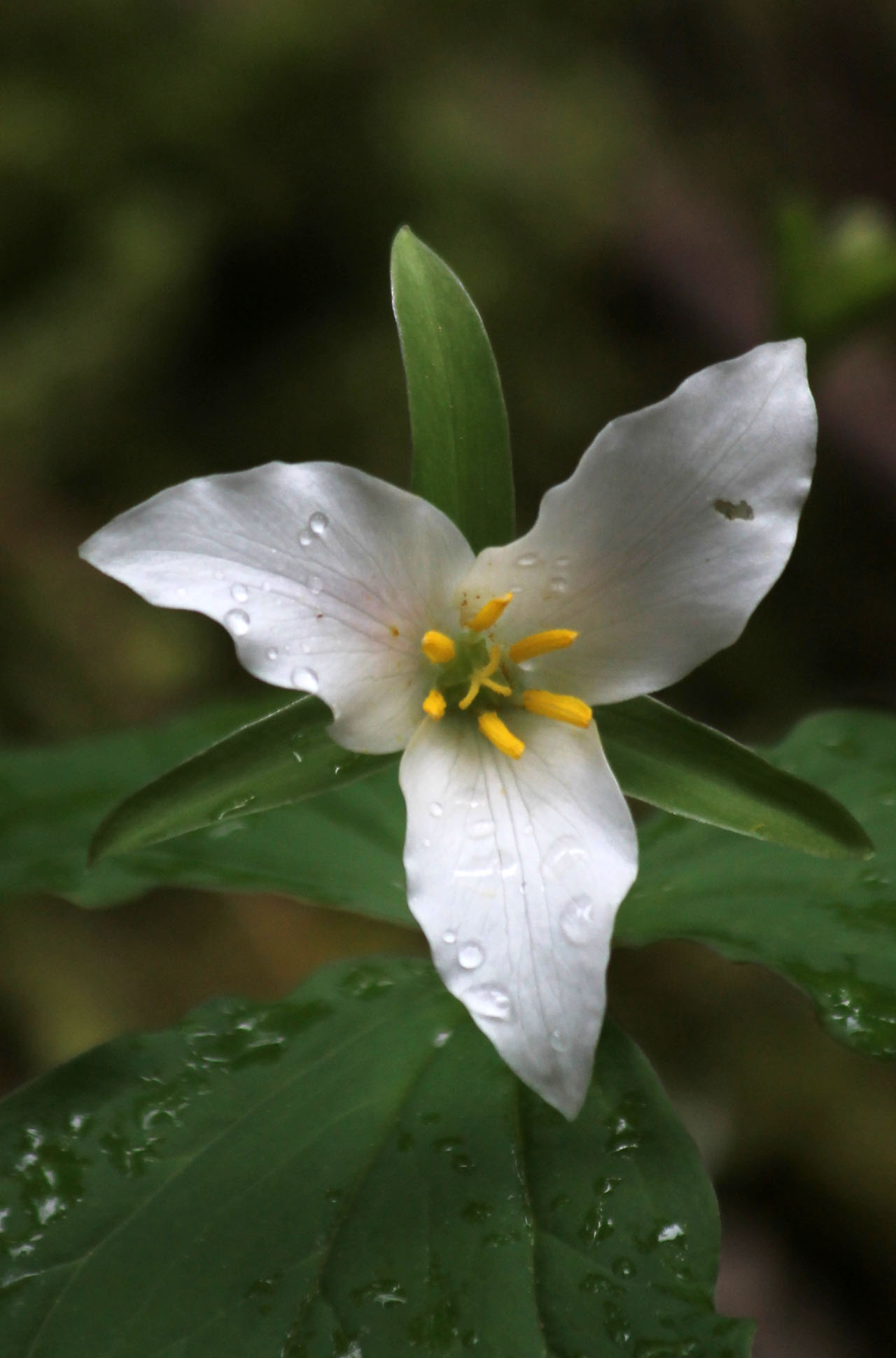
Another beautifully overcast day in Oregon. There’s something about the combination of the weather and the scenery here that just makes it perfect, primordial even, I love it! Today were leaving Eugene and heading out to the coast by way of Newport. I had planned a more direct route to Florence but I ran into a guy that said I wouldn’t want to miss the scenery between Newport and Florence, turns out he was correct. Before we left though there was one important matter to take care of, a wildflower guidebook. I’m spoiled with my Newcomb’s Guide for back home, there just isn’t anything that compares to it in my opinion. With all the flowers we’ve been seeing I wanted to know the species names, that’s just me!
Here’s a couple wildflowers we found along the way today.
Tomorrow we head out toward the coast to start our tour down the PCH (Pacific Coast Highway).
Day 2 ~ To the Coast
Another beautifully overcast day in Oregon. There’s something about the combination of the weather and the scenery here that just makes it perfect, primordial even, I love it! Today were leaving Eugene and heading out to the coast by way of Newport. I had planned a more direct route to Florence but I ran into a guy that said I wouldn’t want to miss the scenery between Newport and Florence, turns out he was correct. Before we left though there was one important matter to take care of, a wildflower guidebook. I’m spoiled with my Newcomb’s Guide for back home, there just isn’t anything that compares to it in my opinion. With all the flowers we’ve been seeing I wanted to know the species names, that’s just me!
Here’s a couple wildflowers we found along the way today.

 Once we hit Newport we stopped into the Oregon Coast Aquarium. Aquariums are always fascinating and I never get tired of watching the Harbor Seals swimming around, they do it so effortlessly. We saw Sea Lions, Otters, Octopus, some of the coolest Anemones and other colorful sea creatures. The Sea Nettles were mesmerizing.
After the Aquarium it was time to head to Florence where we were originally going to find a campsite but it got to be so late we just opted for a hotel. Turns out the hotel was the first business establishment to accept my newly minted AARP card….. yessssssss!! turning 50 had it’s perks after all, it still sucks though. Anyway, back to the trip.
If you’ve never been on the Pacific Coast Highway you don’t know what your missing. The State Parks Department of Oregon does a fantastic job. You can’t say that about too many government organizations these days but this one offers you so many opportunities to experience the coast it’s unbelievable.
Once we hit Newport we stopped into the Oregon Coast Aquarium. Aquariums are always fascinating and I never get tired of watching the Harbor Seals swimming around, they do it so effortlessly. We saw Sea Lions, Otters, Octopus, some of the coolest Anemones and other colorful sea creatures. The Sea Nettles were mesmerizing.
After the Aquarium it was time to head to Florence where we were originally going to find a campsite but it got to be so late we just opted for a hotel. Turns out the hotel was the first business establishment to accept my newly minted AARP card….. yessssssss!! turning 50 had it’s perks after all, it still sucks though. Anyway, back to the trip.
If you’ve never been on the Pacific Coast Highway you don’t know what your missing. The State Parks Department of Oregon does a fantastic job. You can’t say that about too many government organizations these days but this one offers you so many opportunities to experience the coast it’s unbelievable.
 Literally every 1/4 to 1/2 mile has a trailhead to the beach or a pull off with the most incredible views. The best way to explain how beautiful it is, is to give an example in time. If you had 20 miles to travel you had better set aside about 4 hours to get that far.
 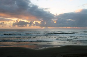 Every turn in the road and there are many, offers you another spectacular view, breath taking actually. As soon as you leave one spot your pulling into another.
Were going back North tomorrow to cover the 15 or so miles we missed last night when it got dark. With any luck we’ll have some dry weather to set up camp for tomorrow night.
Day 3 ~ Florence, Oregon
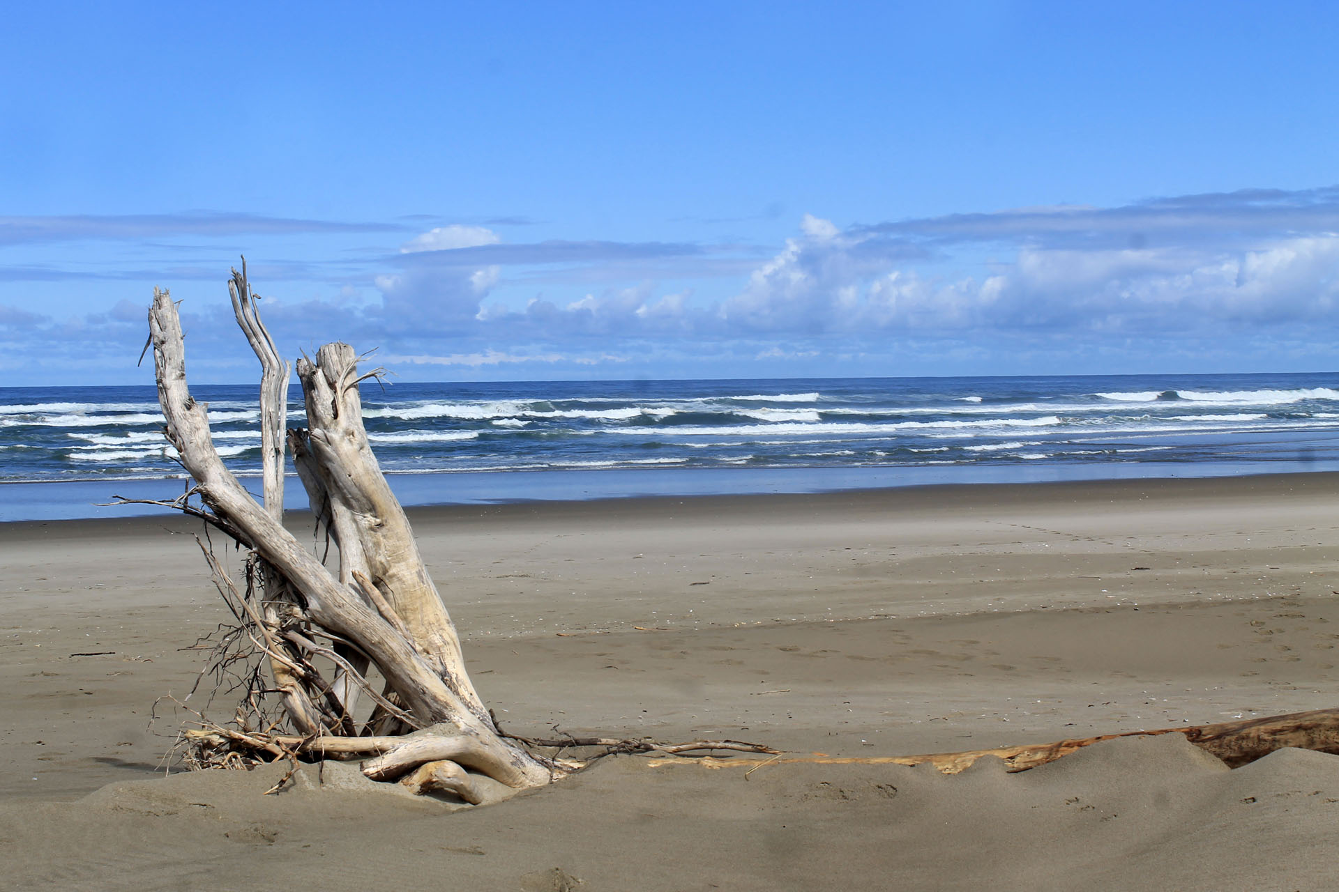
We decided to spend day backtracking a little from last night, Heceta Lighthouse was definitely one of the spots to see that we missed due to nightfall. Heading back North out of Florence was a sign for Heceta Beach a nice side trek. After a couple miles in and still no sign of the coast I kept saying that “we’ll turn around at the next corner thingy”, I’m glad we didn’t turn around at the next corner. Heceta Heights Beach was unlike any beach we have experienced. There were huge logs and pieces of driftwood up and down the entire coast line with some sandy, grassy covered dunes, a truly beautiful place and we spent a couple hours exploring the beach.
Every turn in the road and there are many, offers you another spectacular view, breath taking actually. As soon as you leave one spot your pulling into another.
Were going back North tomorrow to cover the 15 or so miles we missed last night when it got dark. With any luck we’ll have some dry weather to set up camp for tomorrow night.
Day 3 ~ Florence, Oregon
We decided to spend day backtracking a little from last night, Heceta Lighthouse was definitely one of the spots to see that we missed due to nightfall. Heading back North out of Florence was a sign for Heceta Beach a nice side trek. After a couple miles in and still no sign of the coast I kept saying that “we’ll turn around at the next corner thingy”, I’m glad we didn’t turn around at the next corner. Heceta Heights Beach was unlike any beach we have experienced. There were huge logs and pieces of driftwood up and down the entire coast line with some sandy, grassy covered dunes, a truly beautiful place and we spent a couple hours exploring the beach.
 I think we encountered no more than five other people the entire time we were out. Sand dollars were in abundance but trying to find the perfect specimen was few and far between but still an enjoyable way to spend the morning. Any moment spent outdoors tops the best day of work.
 A little further up the road were the Seal Caves, all I can say is, Wow!! These people have a goldmine on their hands, at $14 bucks a head they’re raking it in. Would I stop there again? definitely, but not for the seals. We did see well more than a hundred Stellar Sea Lions but they’re a couple hundred feet below you on the rocks. You need a good lens or some binoculars to really bring them close enough to enjoy. Honestly you can see sea lions and Harbor Seals all around that area on the pull offs so paying to just see them doesn’t make sense.
 The cave, now that was worth the price of admission. Access to the cave is by an elevator that takes you down 210 feet below the cliffs. What an awe inspiring site the cave is, I could have stayed in there for hours watching and listening to the tide come in as well as just marveling at the wonders of nature that excavated out such a place. Would I go again? definitely a big yes but only for the cave experience.
Oddly, and you’ll find this out if you ever go there, the odor on the cliffs is almost palpable and I swear at times I could taste it. The closest comparison I can make is chicken shit, a whole lot of chicken shit. Inside the cave there was no odor or very little that I could tell. I guess it’s safe to say a couple hundred seals a day crapping on the rocks is gonna smell and it ain’t gonna be a good smell.
From the seal caves there were awesome views of Heceta Lighthouse which was less than a mile away. The hike up to the lighthouse has some spectacular views of the cliffs to the South and the beach below where Cape Creek terminates.
The cave, now that was worth the price of admission. Access to the cave is by an elevator that takes you down 210 feet below the cliffs. What an awe inspiring site the cave is, I could have stayed in there for hours watching and listening to the tide come in as well as just marveling at the wonders of nature that excavated out such a place. Would I go again? definitely a big yes but only for the cave experience.
Oddly, and you’ll find this out if you ever go there, the odor on the cliffs is almost palpable and I swear at times I could taste it. The closest comparison I can make is chicken shit, a whole lot of chicken shit. Inside the cave there was no odor or very little that I could tell. I guess it’s safe to say a couple hundred seals a day crapping on the rocks is gonna smell and it ain’t gonna be a good smell.
From the seal caves there were awesome views of Heceta Lighthouse which was less than a mile away. The hike up to the lighthouse has some spectacular views of the cliffs to the South and the beach below where Cape Creek terminates. There’s something about a stream that runs into the ocean that fascinates me, I guess it’s the finality of it. I always think of the Bob Segar tune, “Famous Final Scene” it has this one line “everything must have an end, like an ocean to a stream it’s the famous final scene” Segar had a way with words, I love his stuff.
  The lighthouse itself was under repair, not that it mattered because you wouldn’t be able to see the light in the daytime anyway but what a sight that must be at night in all it’s glory. I regret that we can’t be back here the first week in June when it is relighted.
  While we were admiring the view from the lighthouse cliffs my wife sighted a Gray Whale just below us. Wow!! how cool was that, he passed right in front of us and we saw him surface three times and at one point we could see his entire outline under the waves. I do hope the pic I tried to get comes out. (post note: it didn’t) We spent about four hours total at the lighthouse and then headed back South again. Tonight would be our first tent stay since we arrived and I wanted a place close to the coast to camp.
We ended up driving
While we were admiring the view from the lighthouse cliffs my wife sighted a Gray Whale just below us. Wow!! how cool was that, he passed right in front of us and we saw him surface three times and at one point we could see his entire outline under the waves. I do hope the pic I tried to get comes out. (post note: it didn’t) We spent about four hours total at the lighthouse and then headed back South again. Tonight would be our first tent stay since we arrived and I wanted a place close to the coast to camp.
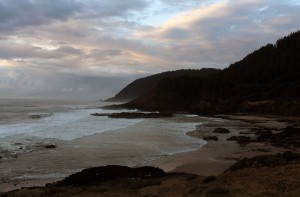
We ended up driving 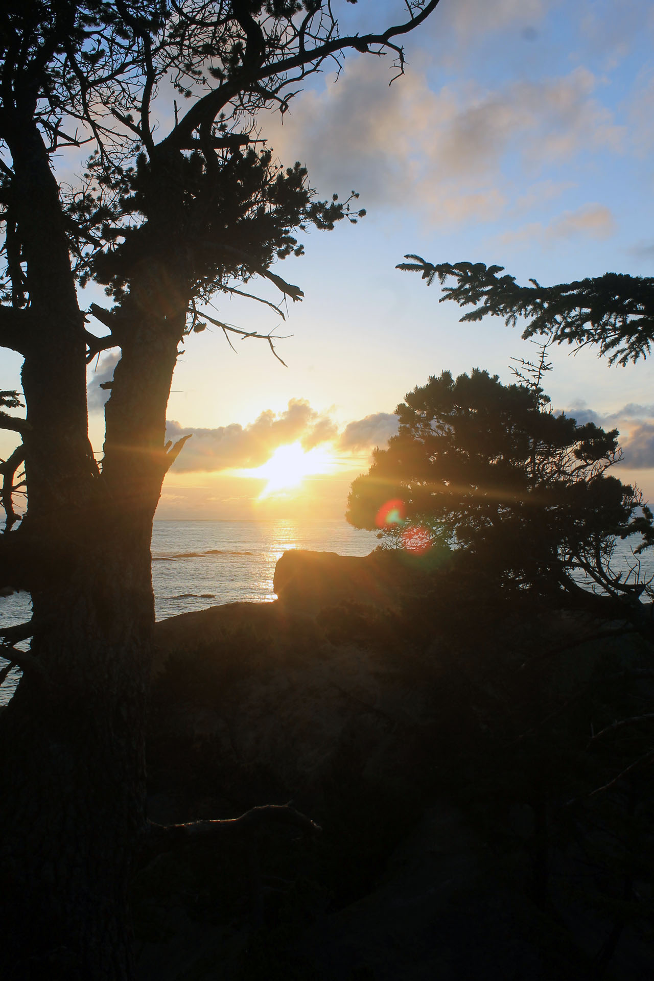 out of Florence an hour or so the Sunset Beach, a truly beautiful place. We set camp up as quick as we could and headed up the trail to the bluffs above the coast.
I hate to sound redundant but beautiful, spectacular, mesmerizing, amazing, gorgeous, there are just so many words to use and your going to hear them every post because every place out here is beautiful, spectacular, mesmerizing, amazing and gorgeous! I’m running out of adjectives.
Day ~ 4 Sunset Bay
We spent the greater part of the day today hiking the trails around Sunset Bay, in particular the Simpson Beach area. We practically had the trails
out of Florence an hour or so the Sunset Beach, a truly beautiful place. We set camp up as quick as we could and headed up the trail to the bluffs above the coast.
I hate to sound redundant but beautiful, spectacular, mesmerizing, amazing, gorgeous, there are just so many words to use and your going to hear them every post because every place out here is beautiful, spectacular, mesmerizing, amazing and gorgeous! I’m running out of adjectives.
Day ~ 4 Sunset Bay
We spent the greater part of the day today hiking the trails around Sunset Bay, in particular the Simpson Beach area. We practically had the trails all to ourselves because over the 4 or 5 hours we spent exploring we only encountered maybe 4 other people
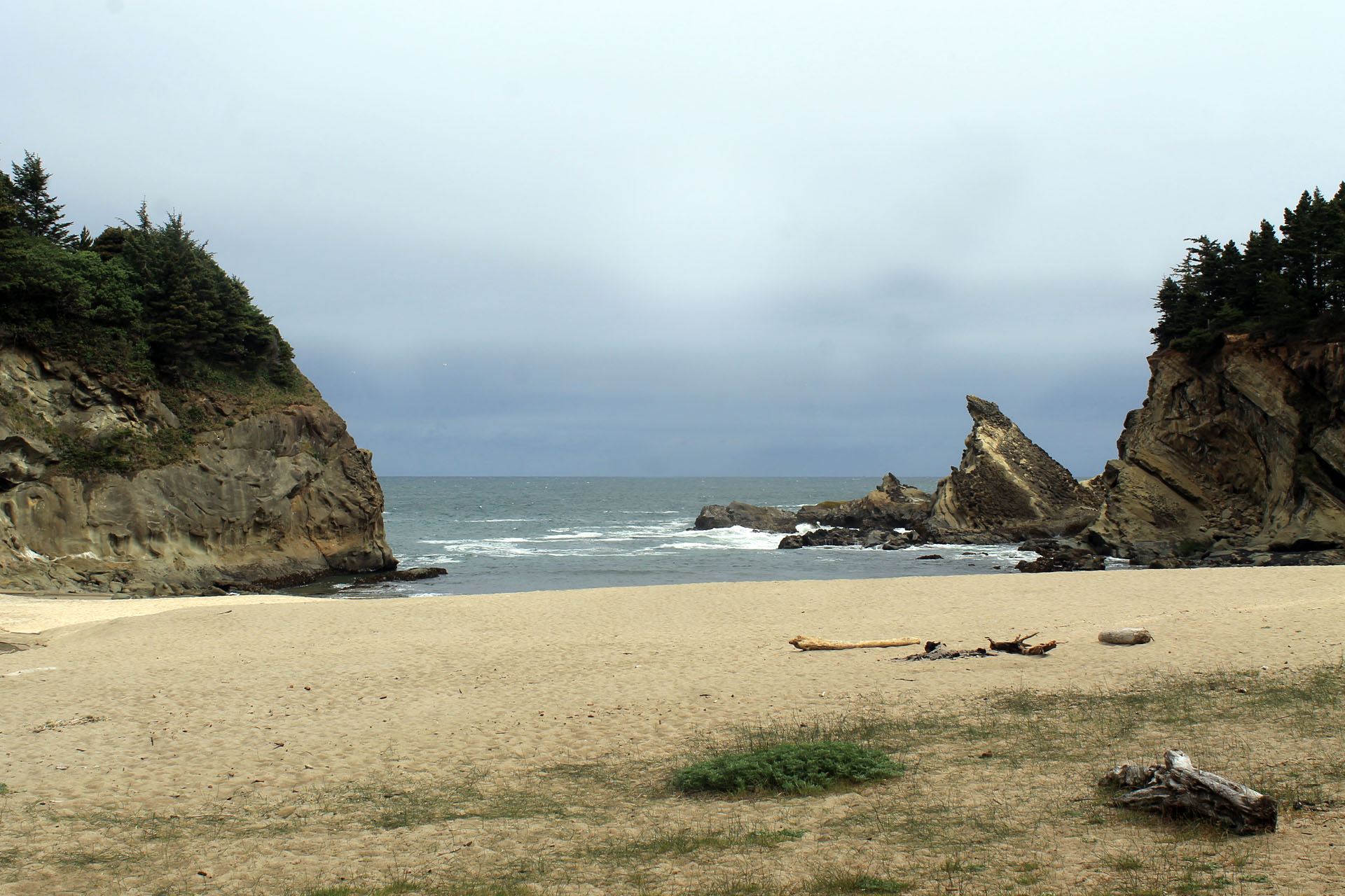 Simpson beach was a wonderful place to hang out and look for Starfish and Anemones which weren’t hard to find, the were everywhere amongst the rocks. Orange, red and purple Starfish and the most colorful anemones.
  I never thought I would see an Anemone outside of the Aquarium so the experience was very cool. Here we could actually touch one and we were surprised to see they would react by constricting themselves just a little. They are beautiful and intriguing creatures.
We found deer tracks on the beach as well as those of an otter before we headed back onto the bluff trail that led to Aruga Point. From the start of our hike we could hear seals somewhere just up ahead. I never realized how far sound carries on the coast or just how loud seals can really be. The seals we had been hearing and looking for the entire hike were about a mile away at Aruga Point. There was a resident population of California Sea Lions that were making all the noise. They were hanging out with some Harbor Seals and Stellar Sea Lions with a few Elephant Seals claiming their own stake of rock to soak up what little sun there was. The trails on the bluffs offered some spectacular views and for me some nail biting moments. I really don’t love heights and walking along the edge of a 200 foot cliff on a 12 inch wide trail with no where to go but straight down is an experience, I am getting a little better at it though. Again for the second day straight my wife spotted a whale just off the coast swimming right by.
I never thought I would see an Anemone outside of the Aquarium so the experience was very cool. Here we could actually touch one and we were surprised to see they would react by constricting themselves just a little. They are beautiful and intriguing creatures.
We found deer tracks on the beach as well as those of an otter before we headed back onto the bluff trail that led to Aruga Point. From the start of our hike we could hear seals somewhere just up ahead. I never realized how far sound carries on the coast or just how loud seals can really be. The seals we had been hearing and looking for the entire hike were about a mile away at Aruga Point. There was a resident population of California Sea Lions that were making all the noise. They were hanging out with some Harbor Seals and Stellar Sea Lions with a few Elephant Seals claiming their own stake of rock to soak up what little sun there was. The trails on the bluffs offered some spectacular views and for me some nail biting moments. I really don’t love heights and walking along the edge of a 200 foot cliff on a 12 inch wide trail with no where to go but straight down is an experience, I am getting a little better at it though. Again for the second day straight my wife spotted a whale just off the coast swimming right by. This one turned out to be two Gray Whales heading North. We were able to view them several times as the surfaced, wow! I love Oregon.
One of the cooler rock formations we came across was Face Rock which is located in Bandon, Oregon. There’s an old Indian legend about Face Rock got it’s name that you can read here. The profile itself is so striking it takes on a personality all of its own.
This one turned out to be two Gray Whales heading North. We were able to view them several times as the surfaced, wow! I love Oregon.
One of the cooler rock formations we came across was Face Rock which is located in Bandon, Oregon. There’s an old Indian legend about Face Rock got it’s name that you can read here. The profile itself is so striking it takes on a personality all of its own.  Leaving Sunset Bay we headed South not to far to spend the night at Blanco Point State Campground where we
  found a pretty nice tent site that we could hear the surf and actually walk a few hundred feet through the woods to an overlook.
Right around sunset we hiked down the trail to view the Blanco Point Lighthouse.
found a pretty nice tent site that we could hear the surf and actually walk a few hundred feet through the woods to an overlook.
Right around sunset we hiked down the trail to view the Blanco Point Lighthouse.
 Of all the gulls we came across the past few days this one just drew me in for some reason
We did get to see some absolutely gorgeous sites today, the kind
that stay way back in the corner of your mind tucked away for eternity until some certain smell, color or minute detail in your day brings that memory flooding back. This is one of those memories I love. I hope to recall this one spot for years to come.
Of all the gulls we came across the past few days this one just drew me in for some reason
We did get to see some absolutely gorgeous sites today, the kind
that stay way back in the corner of your mind tucked away for eternity until some certain smell, color or minute detail in your day brings that memory flooding back. This is one of those memories I love. I hope to recall this one spot for years to come.
 Day 5 ~ South to Brookings
Not the title for Day 5 I had planned as it should have said South to Eureka but we didn’t make it that far. I can’t believe were even still in Oregon. Originally we planned to land in Eugene and just drive through Oregon in one day to hit Redwood National Park. That’s what’s great and what’s not great about keeping an itinerary. The good news is that I love everything we’ve done the past several days and I wouldn’t change a thing. The bad news is the planned stop at Yosemite is out of the question. There just won’t be enough time to drive inland to Yosemite and then back to the coast. We have seven days left and at minimum Yosemite would take up three of those days leaving only four to complete the drive up the coast. I’d rather do what we’ve been doing and leave Yosemite for another visit in the future. I’m very bummed about that but it’s all for the best. I can blame the immense beauty of Oregon for screwing that up. We pretty much spent the entire day driving and stopping at every turnout we came to. There were a couple turn outs that had vantage points of the coast that you had to do a short hike to, maybe a half to 3/4’s of a mile to get to. I hiked a couple of these alone as my wife was getting a little sore back from the hiking and camping, were not as young as we used to be.
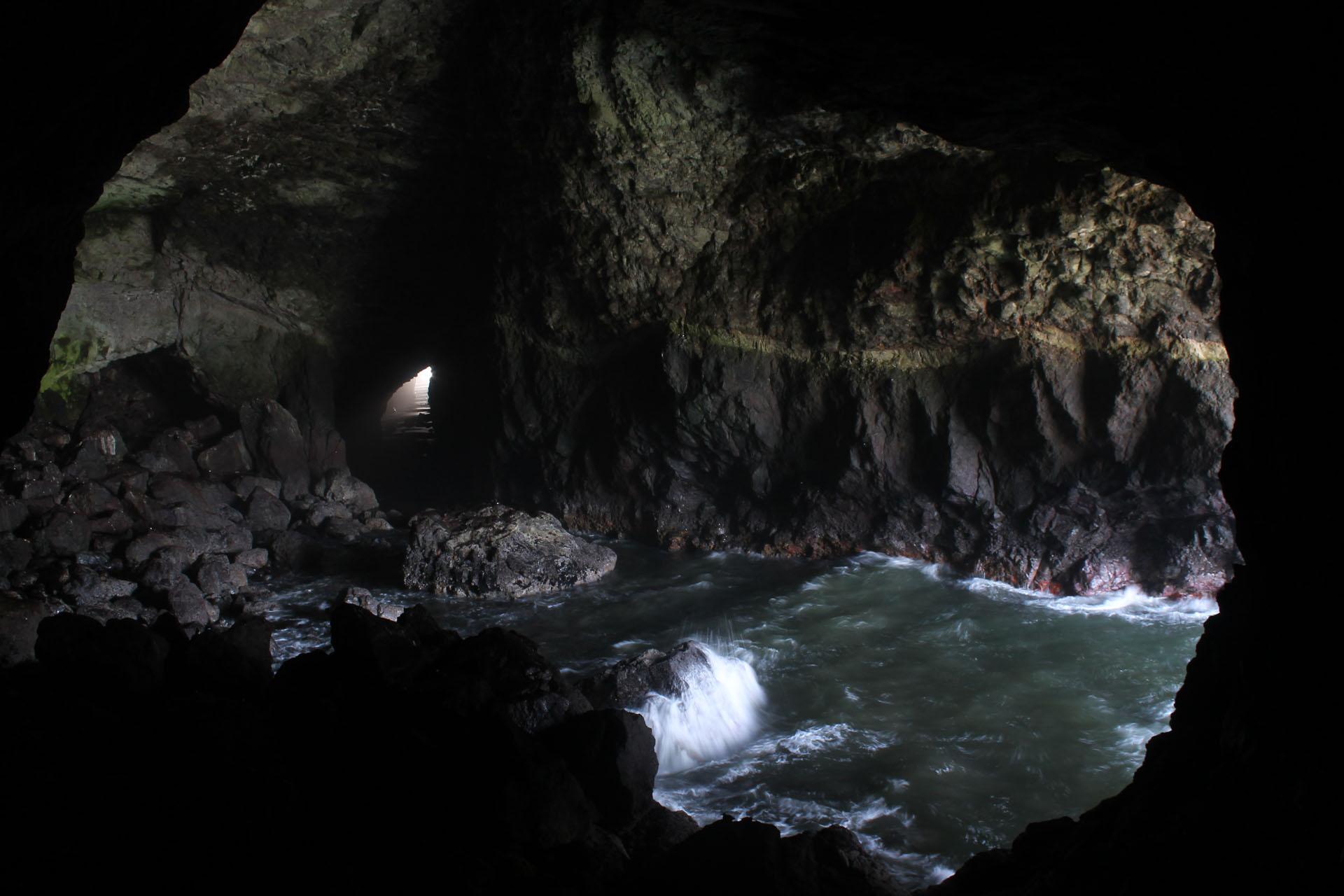
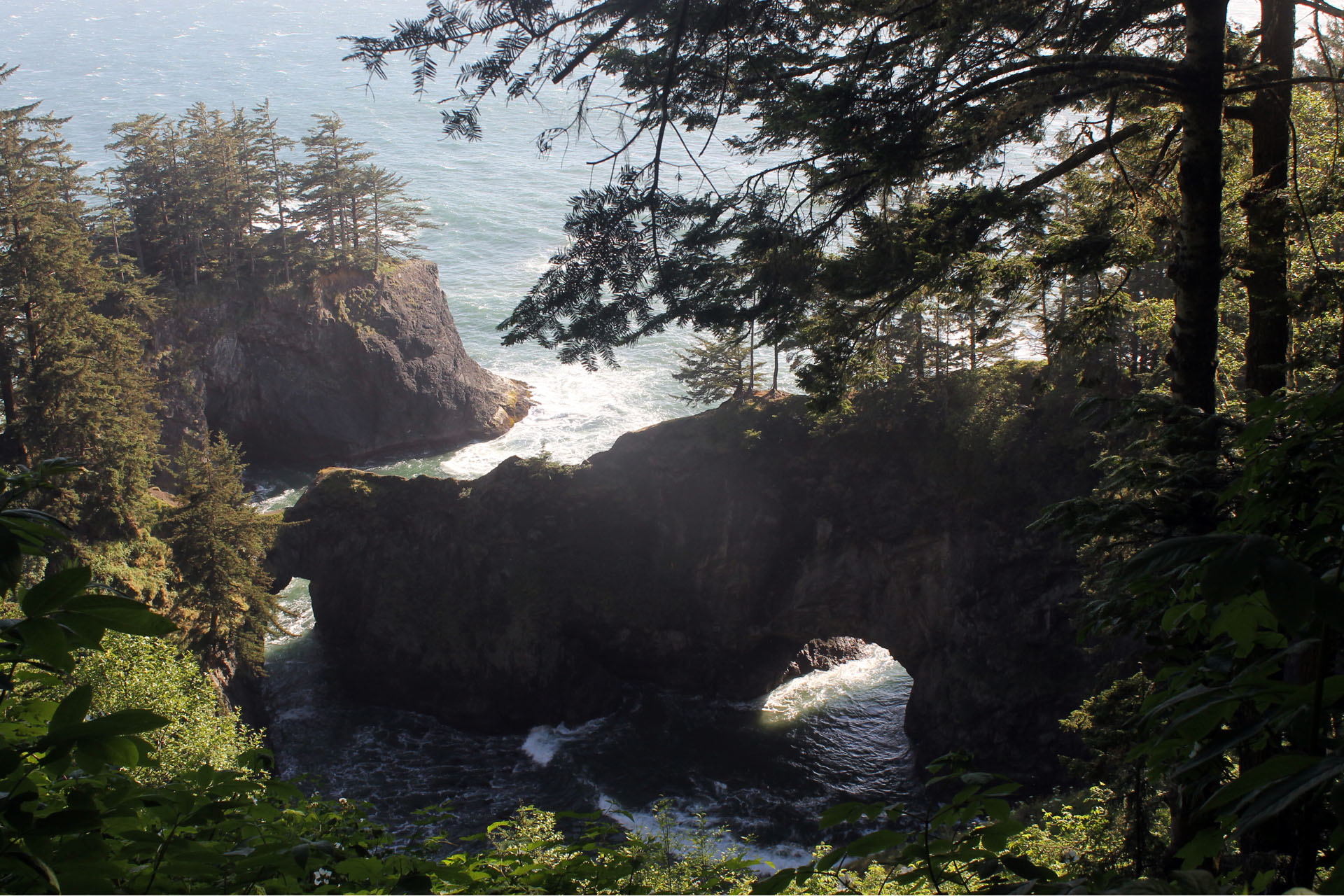
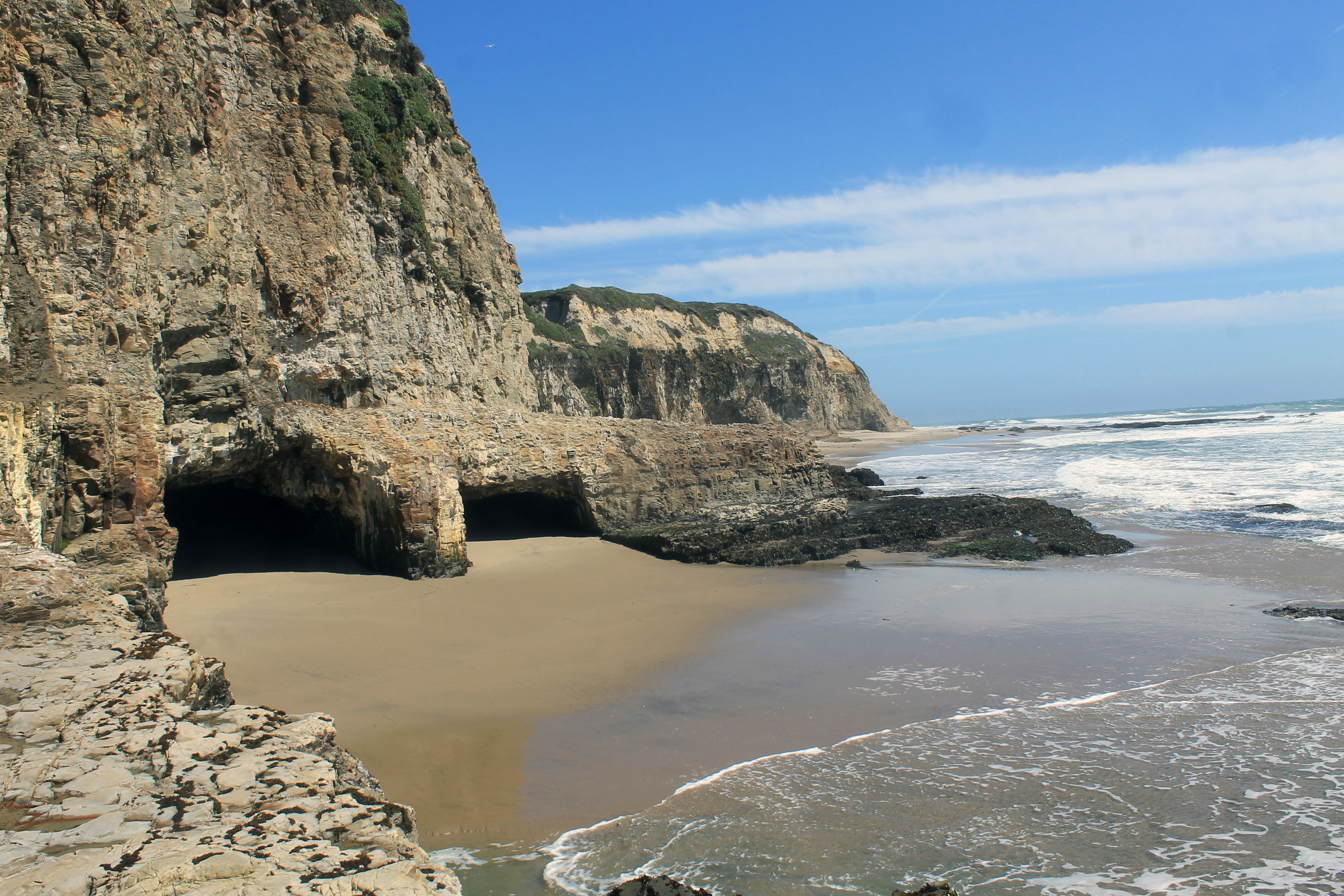
 This particular spot I found totally by accident. We pulled off into a small dirt side road that had barely enough room to do a twenty point turn to get out of. Just a little scary since it was on an incline and you know how your car always does that little roll before you hit the gas. I could just picture us rolling over the 500 foot drop to the rocks below.
After getting the car turned around I was in the mood for a walk so I hiked the mile or so down to the base of this little mountain sticking out of the water. You can’t tell from the picture but there’s a cave from the coast side all the way through the base of the mountain to the ocean side. Some awesome sights and noise as the tide rushed through the cave.
Some of the vantage points were just incredible and I’m definitely getting a little better at getting a little closer to the edge. California Poppies were plentiful along the route.
This particular spot I found totally by accident. We pulled off into a small dirt side road that had barely enough room to do a twenty point turn to get out of. Just a little scary since it was on an incline and you know how your car always does that little roll before you hit the gas. I could just picture us rolling over the 500 foot drop to the rocks below.
After getting the car turned around I was in the mood for a walk so I hiked the mile or so down to the base of this little mountain sticking out of the water. You can’t tell from the picture but there’s a cave from the coast side all the way through the base of the mountain to the ocean side. Some awesome sights and noise as the tide rushed through the cave.
Some of the vantage points were just incredible and I’m definitely getting a little better at getting a little closer to the edge. California Poppies were plentiful along the route.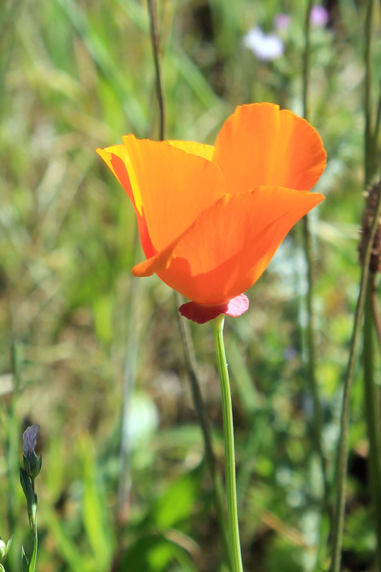 The rock formations are just amazing in Oregon with natural bridges carved through some, tunnels in others, ledges, spires, just some fascinating archeology.
 You can see a little from some of these pictures why it takes so long to drive a mile down the coast. Around every corner is a totally new discovery.
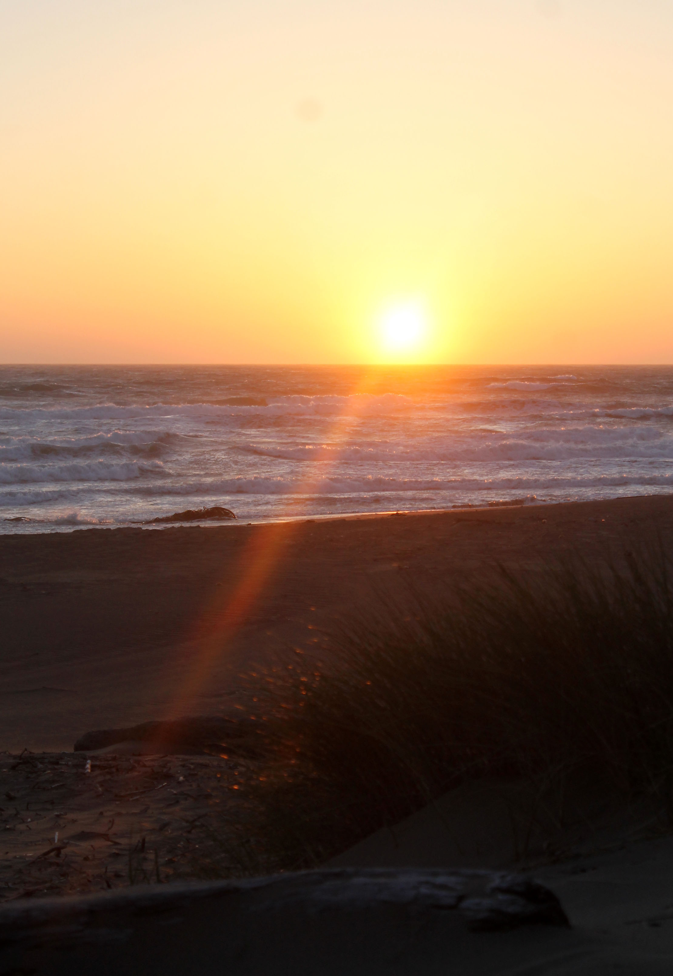
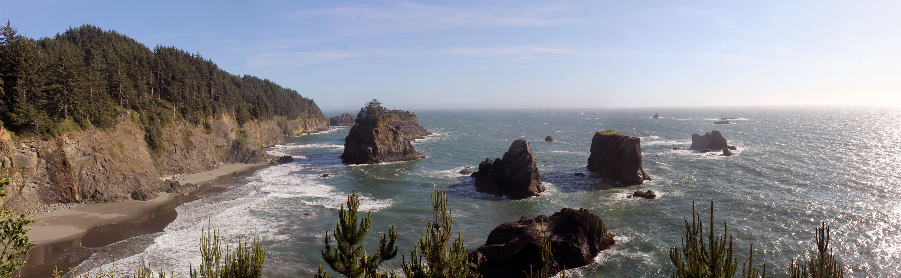 Turns out we would only make it as far as Brookings, Or. This was the first cloudless day on the horizon to see the sun set so I wanted to make the best of that. It was getting late in the day and we decided to get a hotel for the night so we could drive back North up the coast to get a nice spot to watch the sunset, we had stopped at so many. I splurged a little on this one, Best Western right on the beach with a private deck, ocean view and a whirlpool tub with an ocean view. I figured if I wanted her to do any more hiking tomorrow a long soak in a whirlpool tub wouldn’t hurt any. After we booked the room we headed back North, I wanted to get back to one of the overlooks for the sunset but the sun was dropping fast so we ended up pulling into Whaleshead Beach.

 Funny, you never really notice how fast the Earth rotates until you watch the sunset. In a matter of minutes it was gone but the colors were still brilliant for quite some time afterward. Sitting on the balcony back at the hotel listening to the surf with a glass of wine wasn’t to shabby a way to spend the night.
Day 6 ~ Redwoods
Funny, you never really notice how fast the Earth rotates until you watch the sunset. In a matter of minutes it was gone but the colors were still brilliant for quite some time afterward. Sitting on the balcony back at the hotel listening to the surf with a glass of wine wasn’t to shabby a way to spend the night.
Day 6 ~ Redwoods
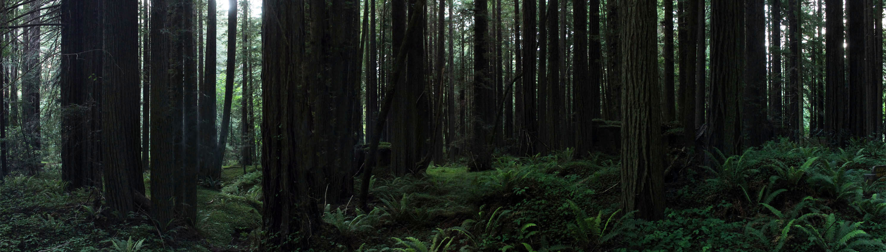
 Redwoods, finally!! Whoa……. not so fast, we just crossed the border into California and what was the first thing we saw? To be honest the first thing we noticed was litter, a lot of litter. That’s one thing that was missing in Oregon, litter. My hats off to the Oregon State Parks Department and Highway Department because they had the most pristine state I have had the pleasure of visiting, great job!! So after the litter, the first thing we saw was Lucky 7 Casino, a major postponement for the days driving tour was in order. I could have easily bypassed it but my wife has a weakness for casinos, I have to admit I like them as well. We decided before we even got out of the car that it was a hundred dollar limit between us. Hmmmm, 30 minutes later as Willie Nelson would say, we were “on the road again”. A quick $20 loss each on video poker and a short visit to the Black Jack table was all it took. We left $80 lighter but had an enjoyable time handing over our chips. Today was exceptionally windy, in fact the windiest of days yet. We had stopped at one pull off to walk the beach a little but I don’t think we went more than 50 yards. The blowing sand was unbearable. No matter which way we walked the wind was whipping from every which way and you had to keep your head down to keep the sand out of your eyes. Probably the closest I could say I’ve been to a sand storm, it wasn’t much fun. We got our first taste of the Redwoods I believe just outside Crescent, Ca. We parked along the side of the road and took a short hike on a coastal trail, the trees and the feel of the forest are truly amazing. We still had quite a way to go so we only did maybe a half mile walk before we headed further South, Humbolt State Park was the destination for the day and we were still fairly far away. I distinctly remember seeing the sign for Prairie Creek State Park and asking the wife if she wanted to drive that way….. no was the reply!!! Ugh, the road actually is a loop road that leaves Route 1, tours through the Redwoods and rejoins it again approximately 30 miles South. I can’t believe we missed that!. We drove in the Southern entrance and headed North for a few miles, shaking my head all the way. Redwoods was on the list and we just detoured one of the biggest parks, damn!! On the bright side if there was one we did manage to see a herd of Roosevelt Elk. Still bummed though! We reached Humbolt State Park around 8 pm. The Avenue of the Giants. Again, not to be redundant but these trees just leave you speechless, the awe factor is over the top. We pulled into Burlington Campground well after dark, we were lucky because there were only a few sites left unoccupied. Were getting pretty adept at setting up in the dark. A quick roast of some Brats, a little wine and smores and we were of the sleep. Definitely looking forward to some hiking tomorrow. Here’s a few panoramas from the day.


 Day 7 ~ Humbolt Redwoods State Park
I’m pretty sure we were the last to crawl into our sleeping bags last night and the first to crawl out this morning. There wasn’t a soul stirring in the campground at 5:30 am. I had the fire roaring, the coffee
Day 7 ~ Humbolt Redwoods State Park
I’m pretty sure we were the last to crawl into our sleeping bags last night and the first to crawl out this morning. There wasn’t a soul stirring in the campground at 5:30 am. I had the fire roaring, the coffee  on and half our stuff packed away before I heard any other noise in the place. Maybe I was just a little more excited than most to get the day started. We headed back North down the Avenue of the Giants to the Founders Grove trailhead. OK, I won’t get into how spectacular the trees are I’ll just say this, you’ll never know how insignificant you really are in the world until you walk amongst the Redwoods. There’s such a primeval feeling hiking through a Redwood Forest. It’s almost as if each tree has it’s personality, some are scared from fire, others are perfect, some have a twenty foot arch completely through them. Others lay on the ground in one gigantic 300 foot long wall.
One fallen tree estimated to be over 1600 years old was defaced beyond belief. How sad it was to see names and initials, thousands of them carved along it’s entire length. It’s hard to describe what I felt when I saw that but it was like a kick in the gut. What makes some idiot think they need to leave or have a right to leave any trace of their meaningless existence on one of Natures greatest accomplishments? I’m actually torn on whether I should even post the picture here but then I thought, yeah, why not. If one of these idiots actually visits this blog and see’s there name then they’ll know what a moron they truly are……. moron!!
on and half our stuff packed away before I heard any other noise in the place. Maybe I was just a little more excited than most to get the day started. We headed back North down the Avenue of the Giants to the Founders Grove trailhead. OK, I won’t get into how spectacular the trees are I’ll just say this, you’ll never know how insignificant you really are in the world until you walk amongst the Redwoods. There’s such a primeval feeling hiking through a Redwood Forest. It’s almost as if each tree has it’s personality, some are scared from fire, others are perfect, some have a twenty foot arch completely through them. Others lay on the ground in one gigantic 300 foot long wall.
One fallen tree estimated to be over 1600 years old was defaced beyond belief. How sad it was to see names and initials, thousands of them carved along it’s entire length. It’s hard to describe what I felt when I saw that but it was like a kick in the gut. What makes some idiot think they need to leave or have a right to leave any trace of their meaningless existence on one of Natures greatest accomplishments? I’m actually torn on whether I should even post the picture here but then I thought, yeah, why not. If one of these idiots actually visits this blog and see’s there name then they’ll know what a moron they truly are……. moron!!  Shaking off the total disgust I have right now we continued on with the day which was only around 9 am to the Rockerfeller Grove which right from the start you could tell was less visited than Founders Grove just by the overall appearance and the fact that there were only two cars in the small parking area. The trail through the Redwoods paralleled the river much of the way and we cut in and out to explore along the river bank as well, looked like some beautiful spots to fish. Unfortunately the season wasn’t set to open for three more days. We spent upwards of three hours exploring this fairly short

 loop trail just under a mile in length and in all that time we only saw 5 other people, we certainly did pick the right time to visit. My only wish were that I had one more week to putt around as I would have loved to spend an extra day here to get a longer hike in amongst the Redwoods. This was truly an incredible place, one of the most mesmerizing I’ve ever been to.
 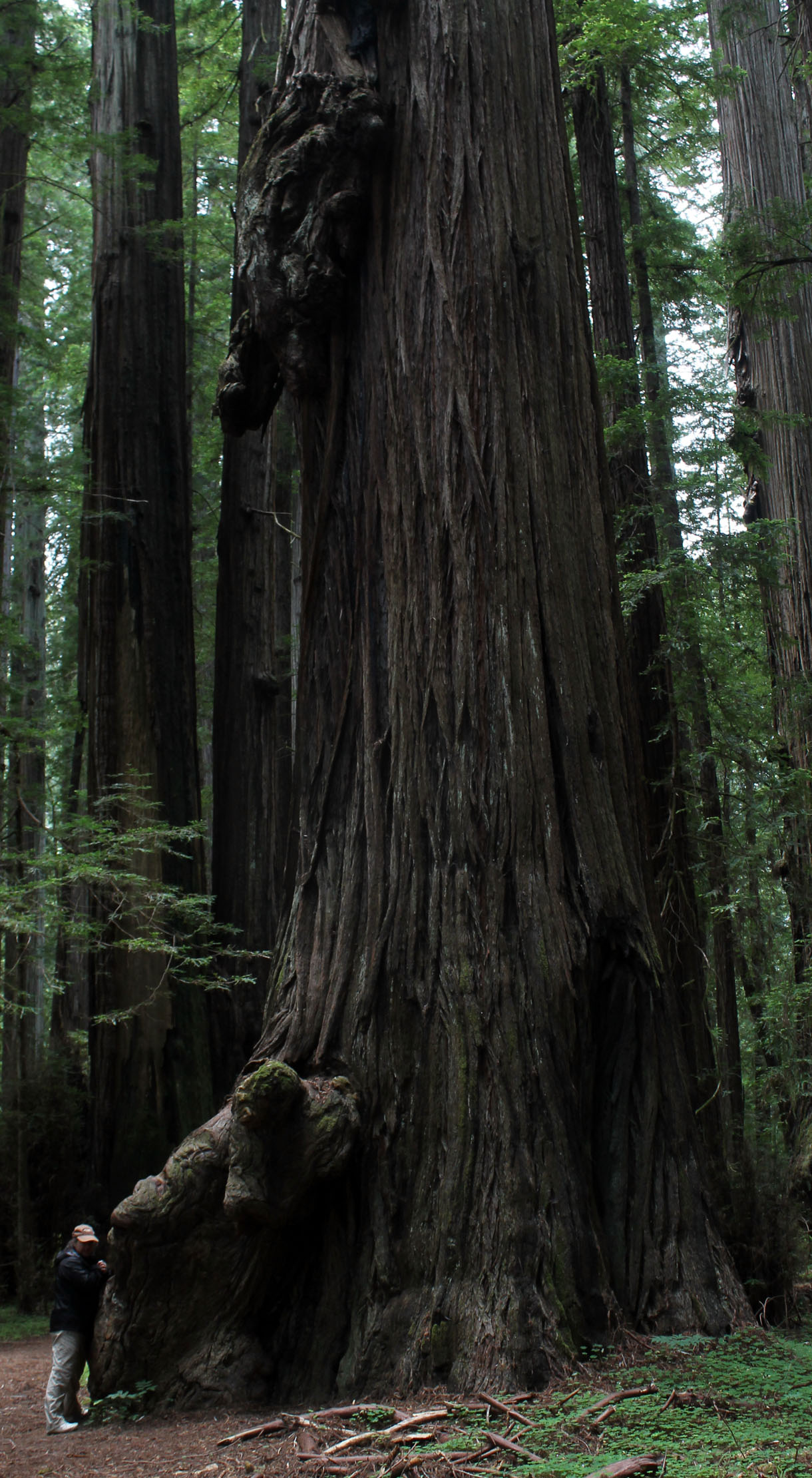 We did a few other short jaunts on some side trails as we headed South again on our way out of the park. One place my wife definitely wanted to stop was the drive thru tree in Myers Flat. We paid the $6.00 bucks and drove down to the tree. They certainly know their livelihood is that tree because they have it secured with 2 or 3 cables to make sure it doesn’t fall. They also had some tree houses made out of two Redwood stumps, neat and as a carpenter I appreciated all the work that went into it. Turns out that wouldn’t be the last drive
  through tree we would visit before the day was over. My wife was excited to see there was also another one along the route we were taking, the Chandelier Tree. This one was located in Leggett, Ca and was a really beautiful shaped tree and massive. We didn’t actually drive through this one because it looked a little tight on the rental and I didn’t want to rip the mirrors off. All in all both trees were a little to touristy, commercial for my tastes but it was something to see since we were there and it makes my wife happy.
We headed toward the coast from Leggett over a very long, steep, windy road. A beautiful drive but a little white knuckle in some spots and slow going. I can’t seem to find the name of the mtn. range we went over but it was a long one. We passed a guy on a bike just at the crest and I can’t believe he had pedaled up that entire thing, hats off to him. We came out to the coast just before sunset and it was some beautiful scenery. There were a few state campgrounds right on the bluffs to stay but it was way to windy and cold for a camp night. The winds had to be 30 mph or more coming off the water and the wind chill had to be around the high 30’s. I certainly would love to have had an RV there with us. We saw two RV’s in one campground and absolutely zero in the second, it definitely would have been nice. After watching the sunset we headed to Fort Bragg to another Holiday Inn Express, time to use the Priority Club Points I accumulated to get a free nights stay.
through tree we would visit before the day was over. My wife was excited to see there was also another one along the route we were taking, the Chandelier Tree. This one was located in Leggett, Ca and was a really beautiful shaped tree and massive. We didn’t actually drive through this one because it looked a little tight on the rental and I didn’t want to rip the mirrors off. All in all both trees were a little to touristy, commercial for my tastes but it was something to see since we were there and it makes my wife happy.
We headed toward the coast from Leggett over a very long, steep, windy road. A beautiful drive but a little white knuckle in some spots and slow going. I can’t seem to find the name of the mtn. range we went over but it was a long one. We passed a guy on a bike just at the crest and I can’t believe he had pedaled up that entire thing, hats off to him. We came out to the coast just before sunset and it was some beautiful scenery. There were a few state campgrounds right on the bluffs to stay but it was way to windy and cold for a camp night. The winds had to be 30 mph or more coming off the water and the wind chill had to be around the high 30’s. I certainly would love to have had an RV there with us. We saw two RV’s in one campground and absolutely zero in the second, it definitely would have been nice. After watching the sunset we headed to Fort Bragg to another Holiday Inn Express, time to use the Priority Club Points I accumulated to get a free nights stay.
 Day 8 ~ South to Wherever
We left Fort Bragg this morning and made it about 12 miles before we first stopped at a trailhead that
Day 8 ~ South to Wherever
We left Fort Bragg this morning and made it about 12 miles before we first stopped at a trailhead that  led out to the coast. We hiked around and found a few wildflowers we hadn’t seen yet like Indian Paintbrush. We also found a new pine to
 add to the MyNature Tree app, Bull Pine which was plentiful in the area.
A little further down the road we started off on a hike to a nearby lighthouse, Point Cabrillo. The trail was actually a paved road which was a major turnoff, we hemmed and hawed back and forth about turning around and it was probably a little over a quarter mile before we just said screw it and turned back toward the car. I just can’t get into walking down a paved road, had at least been a dirt road I think we would have been a little more interested.
add to the MyNature Tree app, Bull Pine which was plentiful in the area.
A little further down the road we started off on a hike to a nearby lighthouse, Point Cabrillo. The trail was actually a paved road which was a major turnoff, we hemmed and hawed back and forth about turning around and it was probably a little over a quarter mile before we just said screw it and turned back toward the car. I just can’t get into walking down a paved road, had at least been a dirt road I think we would have been a little more interested. 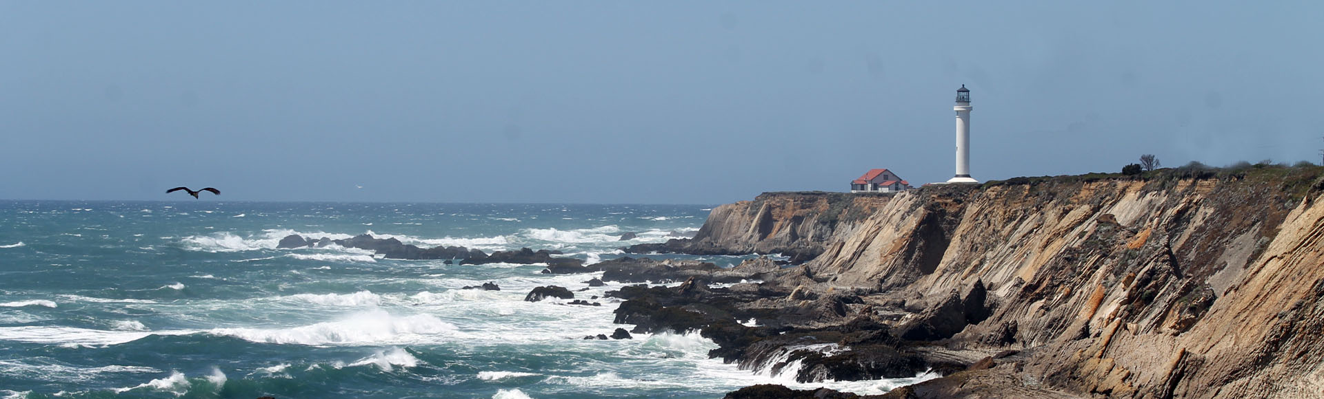 Not to miss out on another lighthouse we came upon Point Arena Light Station further South. This was the first light house that we came upon that you could actually climb the stairs up inside, pretty cool. The view was incredible from the top but what was even more impressive was the wind. I have
  never felt wind like that before. We were able to go out on the
  observation deck that runs around the outside of the light house and I swear if I hadn’t held onto my camera tight it would have blown right away, we had to pretty much pull ourselves along the railing to walk. I had no idea what the wind speed was but it had to be somewhere over 40 mph. All in all a truly unique experience, definitely glad we took the time out of the day to stop.
We stopped at several more spots along the coast before
observation deck that runs around the outside of the light house and I swear if I hadn’t held onto my camera tight it would have blown right away, we had to pretty much pull ourselves along the railing to walk. I had no idea what the wind speed was but it had to be somewhere over 40 mph. All in all a truly unique experience, definitely glad we took the time out of the day to stop.
We stopped at several more spots along the coast before  we ended up at Bodega Bay Campground. This was probably the most private site we stayed at to date. We two fox and a deer before we even registered for the campsite. A quick set up of camp and we were off
 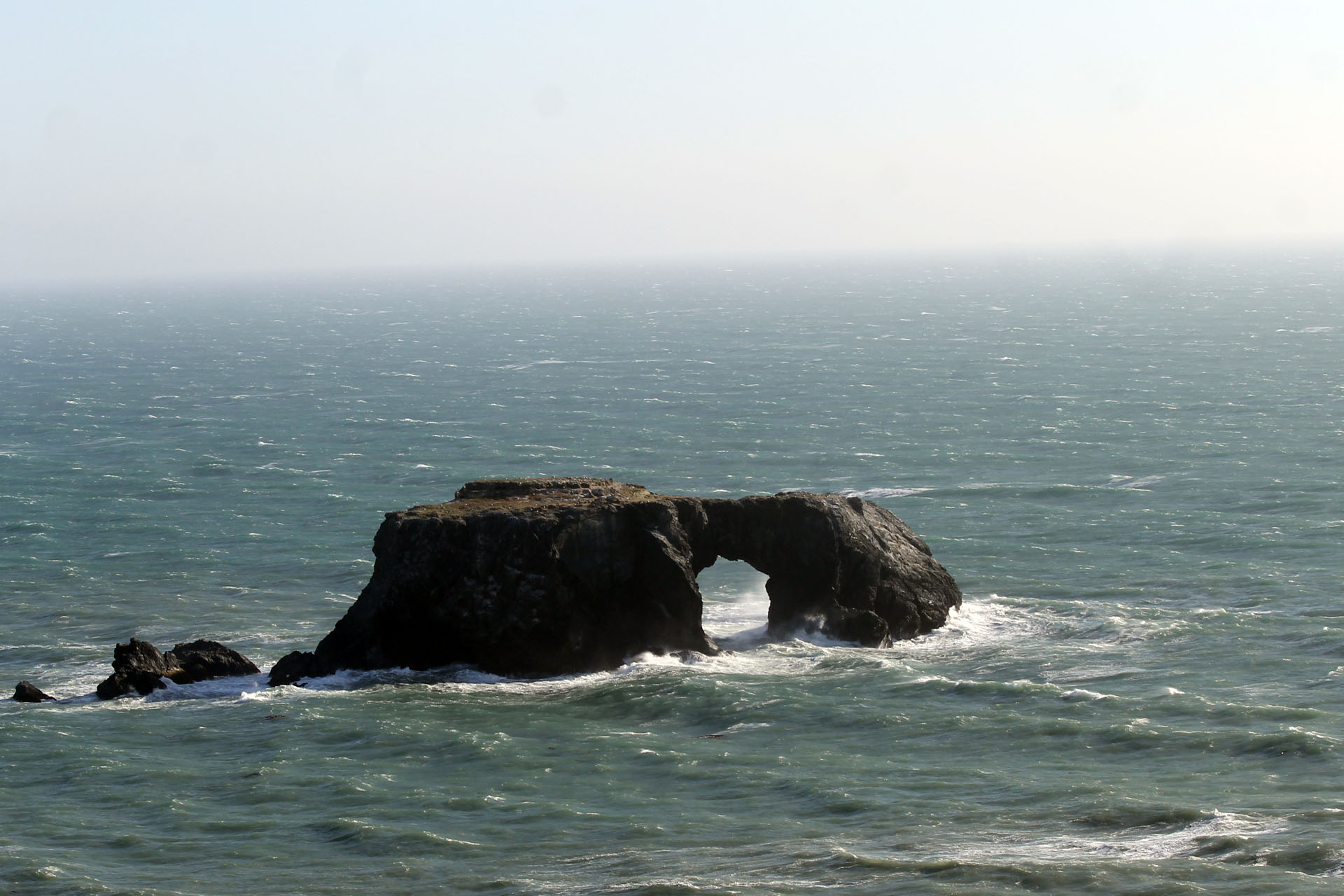 to head back North to a pullout to gather some drift wood for the fire and get some sunset photos. Tenting it was going to be a cold one as frost was actually forecast for the night, nothing a nice roaring fire and a few glasses of wine couldn’t cure, at least until it was time to crawl into the tent.

 I love the sunsets in California, I doubt I could ever get tired of taking pics of them!
Day 9 ~ Bodega Bay Beach to Point Reyes Light Station
Even though we froze our butts off it was a pretty restful night. The campsites at Bodega Bay were one of the best so far with some good privacy.
I love the sunsets in California, I doubt I could ever get tired of taking pics of them!
Day 9 ~ Bodega Bay Beach to Point Reyes Light Station
Even though we froze our butts off it was a pretty restful night. The campsites at Bodega Bay were one of the best so far with some good privacy.
 Once camp was picked up we headed over to Bodega Bay Beach for a long walk. This must be the perfect time of year to visit here because there was not another soul on the beach for as far as we could see. I finally broke down and braved the cold air and fairly cold water
  temps and waded out into the surf to about waist high. I wasn’t out there to long, it was colder than the Atlantic on the Maine Coast which I was about as used to as you can get to cold water.
Beautiful beach though, quiet, surrounded by dunes, a little mist coming in off the ocean and gulls suspended in mid air.
temps and waded out into the surf to about waist high. I wasn’t out there to long, it was colder than the Atlantic on the Maine Coast which I was about as used to as you can get to cold water.
Beautiful beach though, quiet, surrounded by dunes, a little mist coming in off the ocean and gulls suspended in mid air. You couldn’t get it any more picturesque than this. Always sad to have to leave some beautiful place in the middle of the morning and we always had to. Fortunately the next place was always just as awesome.
Point Reyes Light was one of the places I knew before hand I wanted to go to. What I hadn’t expected was that it was over 25 miles out of the way. That’s quite a detour when we had it figured out we needed to make 100 miles a day to get to Santa Monica to pack up and
You couldn’t get it any more picturesque than this. Always sad to have to leave some beautiful place in the middle of the morning and we always had to. Fortunately the next place was always just as awesome.
Point Reyes Light was one of the places I knew before hand I wanted to go to. What I hadn’t expected was that it was over 25 miles out of the way. That’s quite a detour when we had it figured out we needed to make 100 miles a day to get to Santa Monica to pack up and  ship out all our gear before our flight. A hundred miles doesn’t sound like much but when you consider that we had only been averaging around 85 miles a day this 50 mile detour was a pretty big thing. The one thing that pissed me off was that about half way there they had a sign with the hours the lighthouse was open, this wasn’t one of those days. Why would they wait to post the sign twelve miles into the trip? It’s not like this road goes anywhere else, they should have the days of operation posted right back on Route 1 so you can decide at that point on continuing on or not. Anyway, after what seemed like well over an hour of driving we finally reached Point Reyes. There was the usual sweeping views of the coast and high cliffs to sit and watch the ocean. The staircase to the lighthouse was gated off so we were left to view it with our binoculars and get a few long range shots with the camera. We searched the water for passing Grey Whales but saw none. A short distance up the road was Chimney Rock and there was a small pull off to view the Elephant Seals that were basking in the sun on the beach far below. It was a nice spot but we didn’t get a lot of “awe” for such a long side trip. Had the lighthouse been open for tours I’m sure my opinion would have been different.
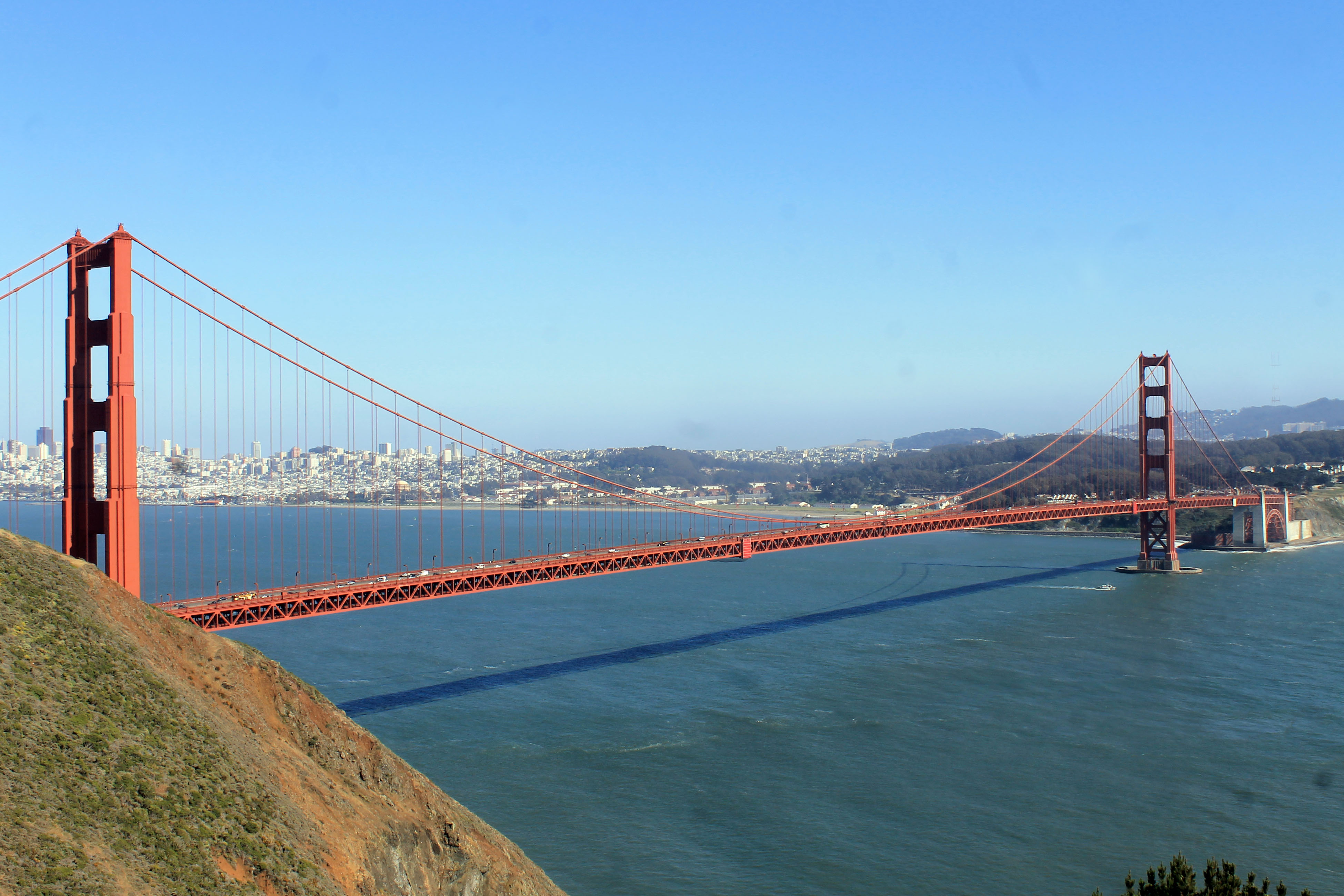 Now we had to hurry up and make some time, I wanted to be on the other side of San Francisco to a campground before dark. There was also the small detail of finding and In & Out Burger for dinner. If you’ve never been to an In & Out Burger you just wouldn’t understand the importance here. In & Out has the best fries and burger you’ll ever have. Everything is fresh cooked while you wait, no comparison with any other burger joint whatsoever. If you’ve never been to one make sure you do, you won’t be sorry. What a sight when the Golden Gate Bridge comes into view, incredible! We quick got off the highway and drove up Hawk Hill which was really crowded with traffic. We did manage to get a parking spot to get a great view of the bridge as well as a few photos. Crossing the Golden Gate was another matter all together. It took us nearly an hour to get across with all the traffic. It wasn’t really stop and go as much as it was stop. The toll booths were at the South end and somehow I got boxed into the Easy Pass lane and couldn’t get out… oopppss! sorry about the six bucks, I’m sure they’ll bill the rental company for that and I’ll get a mysterious charge on my credit card at some point. $6.00 a car and an hour in traffic kinda made me wonder just how much they make off this bridge. In the brief few minutes I looked around Google I came up with an average of 55,000 toll transactions per day which relates to $275,000.00 per day in collected tolls. Not bad Huh? Put that into a yearly figure and it equals out to $100,375,000.00 dollars. I gotta get myself a toll bridge someday. Our GPS was a little shaky finding the closest In & Out and we did a few circles on the freeway. In fact we did so many circles that I didn’t even know where we were anymore but as luck would have it we finally by some small miracle ended up right in front of In & Out. Yes, the meal was delicious and worth all the trouble of finding it. It was right
 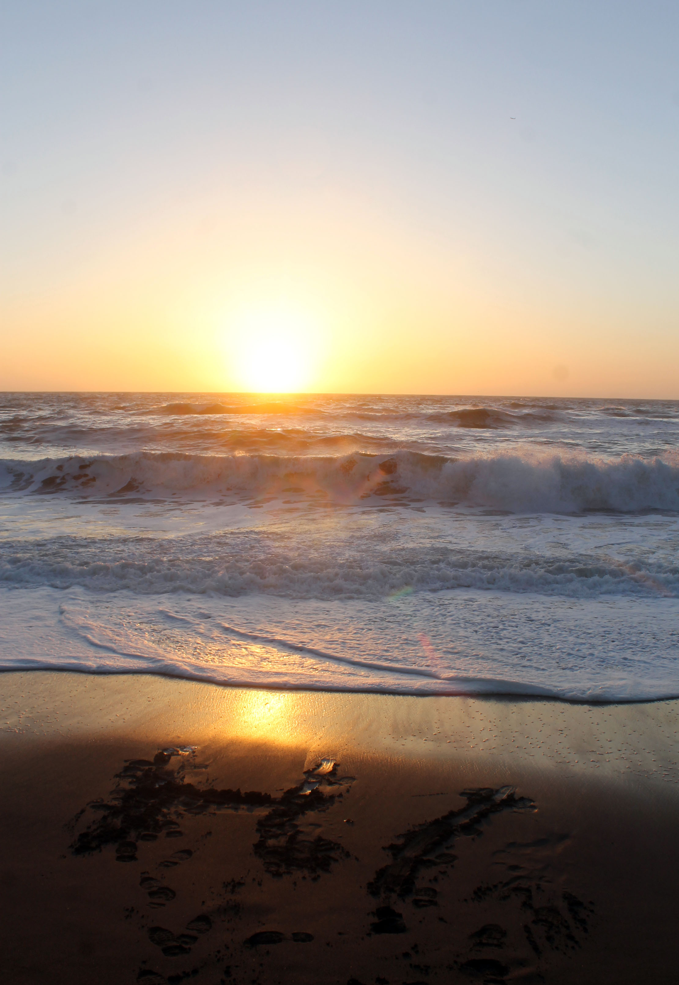 around 7 pm and obvious that we weren’t going to make any campgrounds tonight. It wasn’t like you had to twist my arm either to stay in another hotel.
We ended up at the Holiday Inn Express in Pacifica. Wow what a beautiful spot, right on the beach. We sat and watched a couple Harbor Seals in the surf and witnessed another gorgeous California sunset.
Talk about laid back nights, the beach, the surf, the sunset, I could definitely get used to this!
Day 10 ~ Pigeons Point to Monterey
around 7 pm and obvious that we weren’t going to make any campgrounds tonight. It wasn’t like you had to twist my arm either to stay in another hotel.
We ended up at the Holiday Inn Express in Pacifica. Wow what a beautiful spot, right on the beach. We sat and watched a couple Harbor Seals in the surf and witnessed another gorgeous California sunset.
Talk about laid back nights, the beach, the surf, the sunset, I could definitely get used to this!
Day 10 ~ Pigeons Point to MontereyA bit of a late start to the day, so we decided to search out a coffee house to get some extra energy. If there is one thing I’ll remember from this trip it will be m discovery of Mocha Lattes. I was never a fan of coffee, loved the smell but hated that bitter taste. Wow! those things are a small fortune. When we finally got back on the road we stopped at Bean Hollow which was a pull off with a scenic overlook.
 We must have spent an hour or so just watching the surf pounding against the rocks throwing spray 20 feet up into the air. Funny something as violent as that can be so peaceful.
We continued up Route 1 and came upon Pigeon Point Light Station, of course we stopped! There was definitely some beautiful scenery with the wildflowers in bloom almost everywhere you looked. Again searching the ocean for some passing Grey Whales turned up nothing but I was entertained for quite a long time by a pair of Harbor Seals that were enjoying surf.
We must have spent an hour or so just watching the surf pounding against the rocks throwing spray 20 feet up into the air. Funny something as violent as that can be so peaceful.
We continued up Route 1 and came upon Pigeon Point Light Station, of course we stopped! There was definitely some beautiful scenery with the wildflowers in bloom almost everywhere you looked. Again searching the ocean for some passing Grey Whales turned up nothing but I was entertained for quite a long time by a pair of Harbor Seals that were enjoying surf.  There was a really good display of the history of Pigeon Point Light in one of the out buildings on the property. The history of all the ship wrecks in the area was fascinating. I definitely enjoyed the couple of hours we spent here.
 I can’t remember the next place we stopped but it was a nice sandy beach right on the side of the road. Again, hardly anyone was there, maybe it was the 20 mile an hour winds but I didn’t mind because I loved the solitude. We walked close to a mile up the beach just exploring.
 There was a rock outcrop stretching out into the water that we climbed over and were surprised to find two pretty cool caves to look around in.
 The tide was coming in so I was a tad nervous about getting caught on the wrong side of that rock formation. It was a long walk back into the wind but still beautiful with every step. We made it through Santa Cruz by 3 pm and set our destination for the night as Monterey. Before we hit Monterey we stopped at another beach to look around. We weren’t keeping a very good log of names today because I have no idea what beach this was. We saw a dozen or so Egrets fishing in the shallows of a small bay and one big brown clump laying on the shoreline that turned out to be an Otter, a very tired Otter. He was more interested in sleeping than
  with me taking his picture.
I managed to get some nice pics and several more of two other Sea Otters that were diving and cracking open shells for their dinner. Was nice to see so many otters in one spot. The walk on the beach was fairly short as the wind kicked up again so we headed back to the car to continue on to Monterey. We got settled in right around 7: 30 or so and decided rather than watch another spectacular California sunset that we would check out Fisherman’s Wharf. Turned out to be a great decision, Fisherman’s Wharf is packed with little shops and an abundance of restaurants. Each establishment had their specials plated on display outside the entrance and the hostesses were scooping out small samplers of their Clam Chowder.
with me taking his picture.
I managed to get some nice pics and several more of two other Sea Otters that were diving and cracking open shells for their dinner. Was nice to see so many otters in one spot. The walk on the beach was fairly short as the wind kicked up again so we headed back to the car to continue on to Monterey. We got settled in right around 7: 30 or so and decided rather than watch another spectacular California sunset that we would check out Fisherman’s Wharf. Turned out to be a great decision, Fisherman’s Wharf is packed with little shops and an abundance of restaurants. Each establishment had their specials plated on display outside the entrance and the hostesses were scooping out small samplers of their Clam Chowder.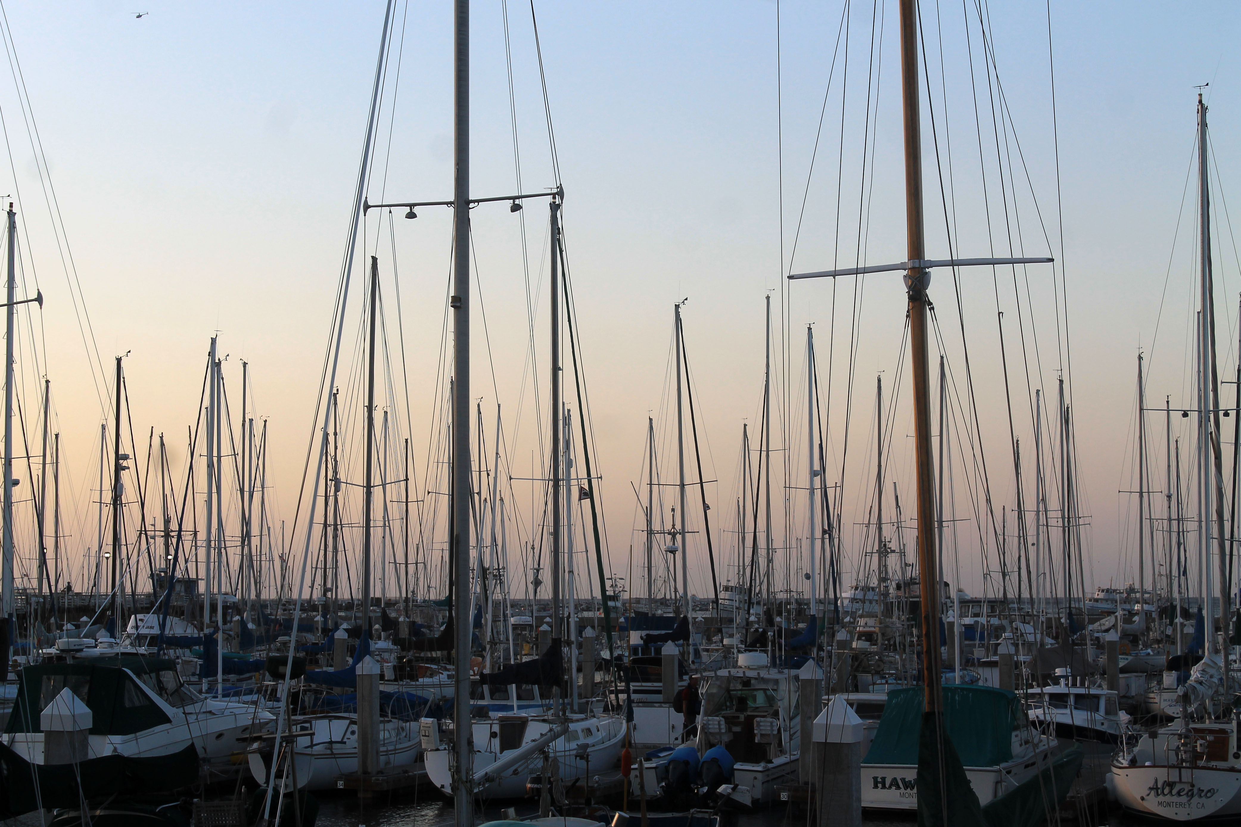 These were by far the best Clam Chowders I had ever tasted. Domenico’s Restaurant lured me in with the special they had displayed which was a pasta and seafood dish. I really can’t say which was better the food or the view. We were probably their last table of the night so they sat us all the way in the back corner. We could see the harbor out the side and back windows. What a spectacular view with the full moon rising over the wharf filled with ships, just incredible. After our meal we walked down to the end of the wharf to check the whale watch schedule. It was pretty much a no brainer where we would be headed the next morning, I can’t pass up a whale watch.
Day 11 ~ Fisherman’s Wharf to Big Sur
A quick drive down the road and we were back at Fisherman’s Wharf at 9 am for the whale watch trip. We had a while to wait to board the ship which I didn’t mind at all since I could hear some Stellar Sea Lions somewhere making a commotion. It didn’t take to long to find where all the noise was
These were by far the best Clam Chowders I had ever tasted. Domenico’s Restaurant lured me in with the special they had displayed which was a pasta and seafood dish. I really can’t say which was better the food or the view. We were probably their last table of the night so they sat us all the way in the back corner. We could see the harbor out the side and back windows. What a spectacular view with the full moon rising over the wharf filled with ships, just incredible. After our meal we walked down to the end of the wharf to check the whale watch schedule. It was pretty much a no brainer where we would be headed the next morning, I can’t pass up a whale watch.
Day 11 ~ Fisherman’s Wharf to Big Sur
A quick drive down the road and we were back at Fisherman’s Wharf at 9 am for the whale watch trip. We had a while to wait to board the ship which I didn’t mind at all since I could hear some Stellar Sea Lions somewhere making a commotion. It didn’t take to long to find where all the noise was 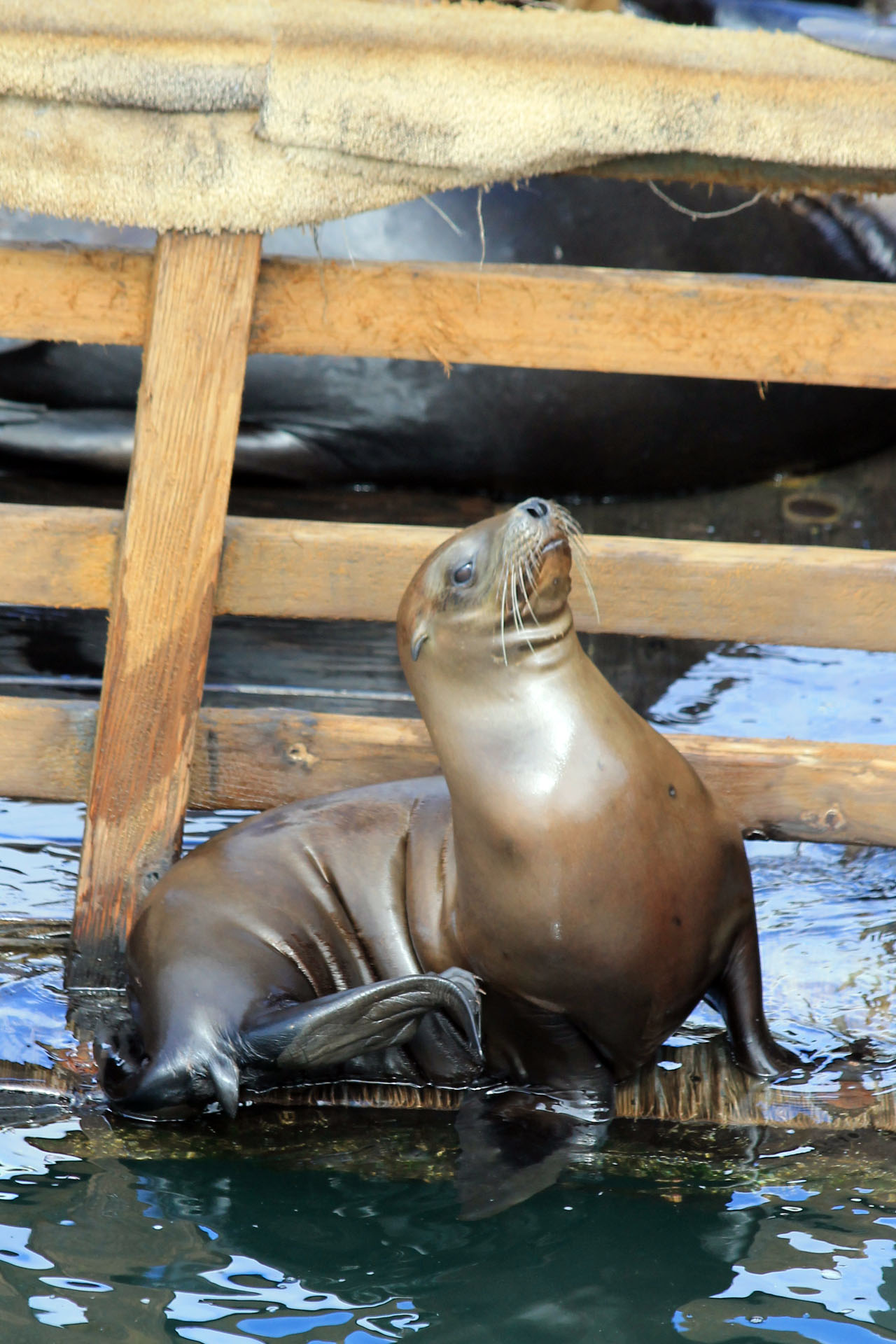 coming from. There was a floating dock that was loaded with sea lions. Sea lions on the deck, sea lions on the railings, sea lions on the buoys, they were everywhere. I had a blast watching them and capturing a few images. The cruise was only supposed to last 3 hours which was perfect, that would leave us more than enough time to get to Big Sur and get a campsite setup and get some hiking in. We were probably less than 20 minutes out of the harbor when we saw several Risso’s Dolphins, a species I had never seen before.
  There were more Stellar Sea Lions in the open water and I did manage one good pic of one swimming full throttle. As with any whale watch I’ve been on there is a lot of down time where you don’t see anything which is OK with me, I’ve always just enjoyed the boat ride. It’s not everyday that you get to cruise the ocean. What was killing me was the onboard Naturalist……. she just would not shut up! The woman talked constantly, it’s great to learn a few things about whales or other marine life but for heavens sake how about a little quiet time. We finally managed to locate a mother Humpback with her calf and we followed them for a good 45 minutes but never saw any more of their profile than their back, no tail, no full body breaching that I’ve always hoped to see. But we did get to see a whale, that put our total for the whole trip since OR at around 6 or 7. What was great about
  seeing the whales from the bluffs along the coast was the peace and quiet of the whole experience because , you guessed it, miss Naturalist talked the entire time the whales were in view. The only escape from her was the return trip where she finally relinquished the microphone, there is a God after all! Back on the road our next stop was Point Lobos State Preserve, ut oh! This was the first sign that the end of our trip wasn’t going to go so well. There were cars parked along both sides of the road at the entrance to the park. Not just a few cars, were talking maybe 60 cars on the East side and 60 cars on the West side of the road. The Ranger at the entrance said it was a crazy day and it certainly was. Parking lots in the park were full and there were people everywhere. This was more like a scene at the mall and it wasn’t for me. Getting outdoors is always my goal but it doesn’t include a
 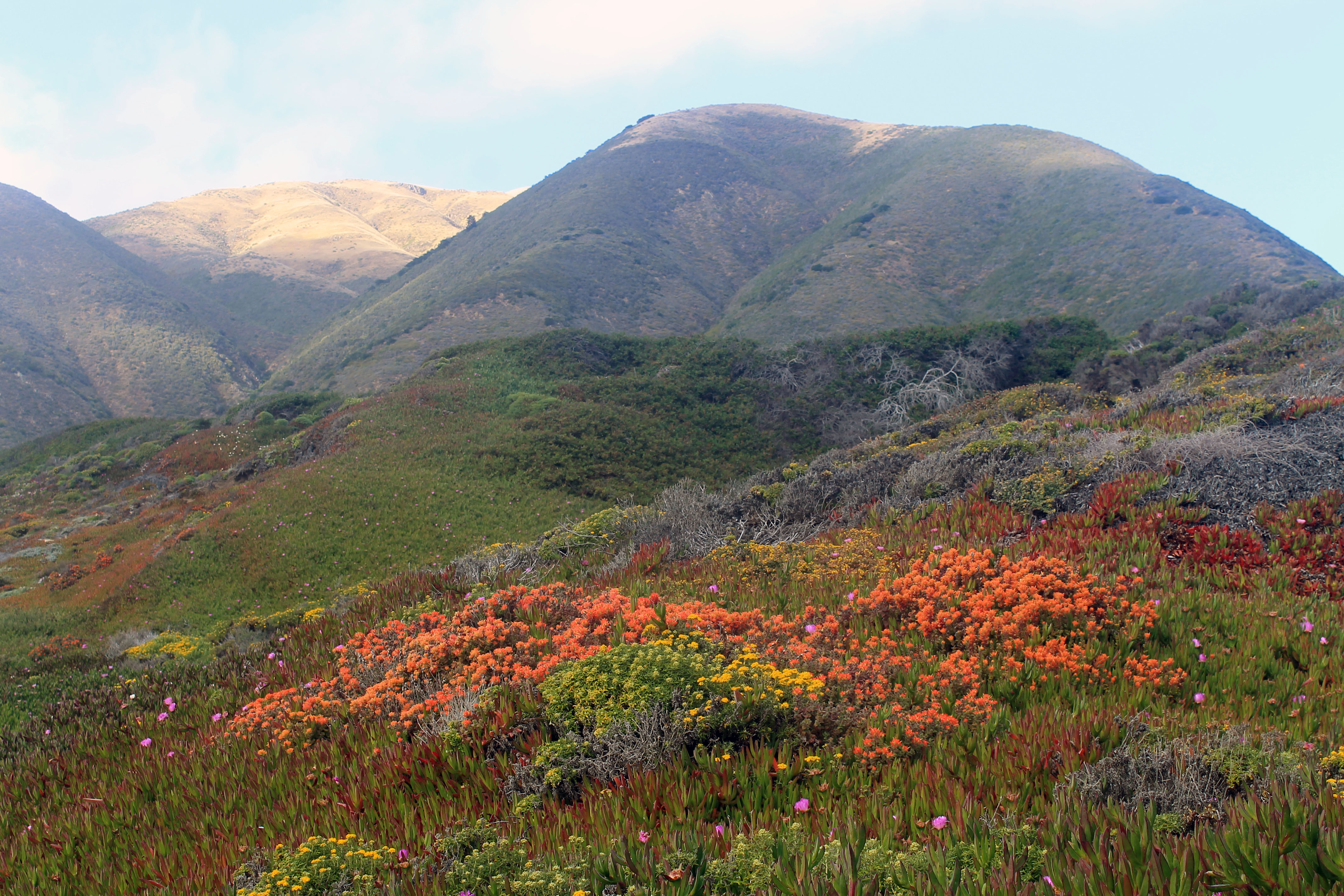 crowd. Memorial Day weekend was here and I never took that into consideration when I first planned this trip. I had no idea the state parks would be swarming with people. All the sudden Big Sur was looking like we may not get a camping spot and I was pretty sure we wouldn’t. Needless to say we didn’t stay more than 5 minutes in Point Lobos. We hit the beach for a nice long walk and to surf watch just outside Big Sur, this was a beautiful spot and I had been here before, very relaxing and an abundance of wildflowers were in bloom.
 The landscape was painted in an array of colors. My big fear of not getting a campsite for the night was assured when we pulled into Andrew Molero State Park. One big sign read “Campsites Full” I still had to walk in to confirm to myself that was the case and indeed it was, bummer. The entire area of Big Sur was crawling with people and everywhere you looked camp grounds were full. A check on the few motels in the area were also full except for one place that had a vacancy for $375.00 for the night. With all the people in the area there was no way I would pay that much to get some hiking in that would pretty much amount to taking a walk in Times Square on a lunch hour. Disappointedly we continued on and stopped at Julia Phieffer Burns State Park to check out the waterfall which is a spectacular site.
 We still had hopes of finding a campsite further South but one after another all the signs said full and the gates were locked anyway. After a long drive we made it to Cambria where we got the last room at a Comfort Inn for a whopping $250.00 for the night. The place was a dive but we needed a place to stay. Had I known the fine for beach camping was only $200 I would have camped on the beach instead. All in all the day started out great but ended up a little depressing.
Day 12 ~ On to Santa Monica
Not the way I envisioned the last day of my so far spectacular trip, waking up in a dive of a motel. I couldn’t get out of there fast enough. We had passed the beach last night in the dark where the Elephant Seals come ashore to rest and moult. The first thing on the agenda was to backtracks the 15 miles or so because I knew my wife would enjoy seeing them as much as I would. You really can’t miss the spot because there is a big sign that says “Friends of the Elephant Seals“. This is a very cool place to stop if you can stand the smell. There are hundreds if not thousands of Elephant Seals lining the beach, what a sight!
We still had hopes of finding a campsite further South but one after another all the signs said full and the gates were locked anyway. After a long drive we made it to Cambria where we got the last room at a Comfort Inn for a whopping $250.00 for the night. The place was a dive but we needed a place to stay. Had I known the fine for beach camping was only $200 I would have camped on the beach instead. All in all the day started out great but ended up a little depressing.
Day 12 ~ On to Santa Monica
Not the way I envisioned the last day of my so far spectacular trip, waking up in a dive of a motel. I couldn’t get out of there fast enough. We had passed the beach last night in the dark where the Elephant Seals come ashore to rest and moult. The first thing on the agenda was to backtracks the 15 miles or so because I knew my wife would enjoy seeing them as much as I would. You really can’t miss the spot because there is a big sign that says “Friends of the Elephant Seals“. This is a very cool place to stop if you can stand the smell. There are hundreds if not thousands of Elephant Seals lining the beach, what a sight! 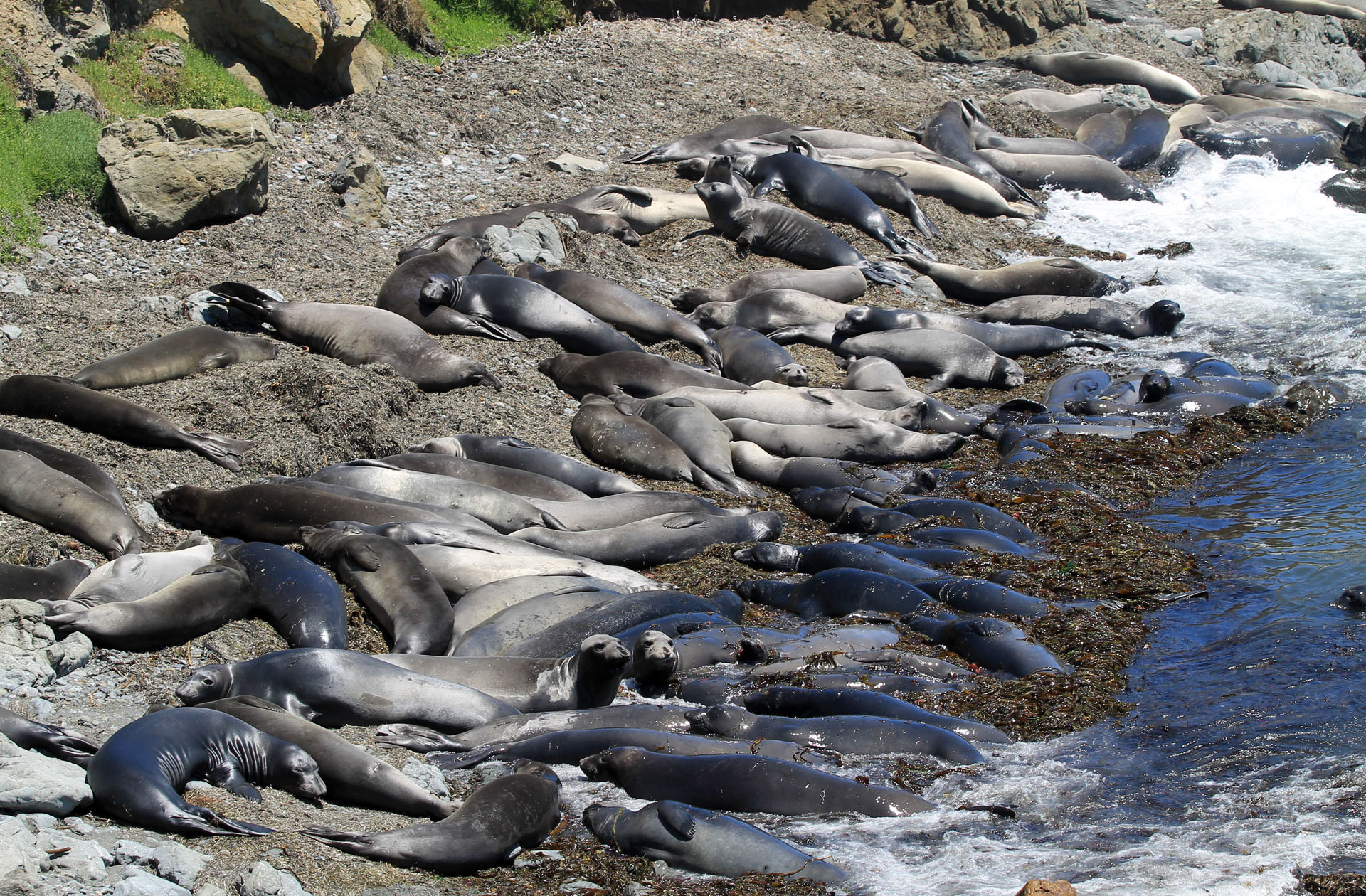 If you were to park at the North end of the parking lot you can hike the coastal trail and get a more private and very less crowded view of the seals as well as a very less aromatic view, the odor can be overpowering to say the least. There’s also a pull off south of the main parking lot that literally put you on top of a small section of beach that is crowded with Elephant Seals. I spotted no less than 8 Sea Otters hanging out in the Kelp beds at this pull off. I could never get bored watching Sea Otters. We headed back South and to a detour into Hearst Castle which really didn’t interest me but my wife wanted to see it.
  The place was packed and the tours were sold out which I certainly didn’t mind. We looked around a little in the main building and even though I would have enjoyed the architecture of the place, the decorations, furniture and all were to ornate for my tastes and my wifes as well. In the end she didn’t mind that we couldn’t do a tour. We stopped again to hit the beach pretty much in the middle of nowhere. We sat and watched the surf and took a short nap against the rocks, it was a pretty peaceful place and sadly we had to leave for our final destination. There wouldn’t be anymore stops until we got to Santa Monica, bummer!! Not sure what it is about Santa Barbara but each time I’ve been through there the traffic is horrible. I think it took us no less than and hour and a half to get through traffic there, stop and go for several miles. We took the opportunity to face chat with our daughter who was holding down the fort while we were gone.
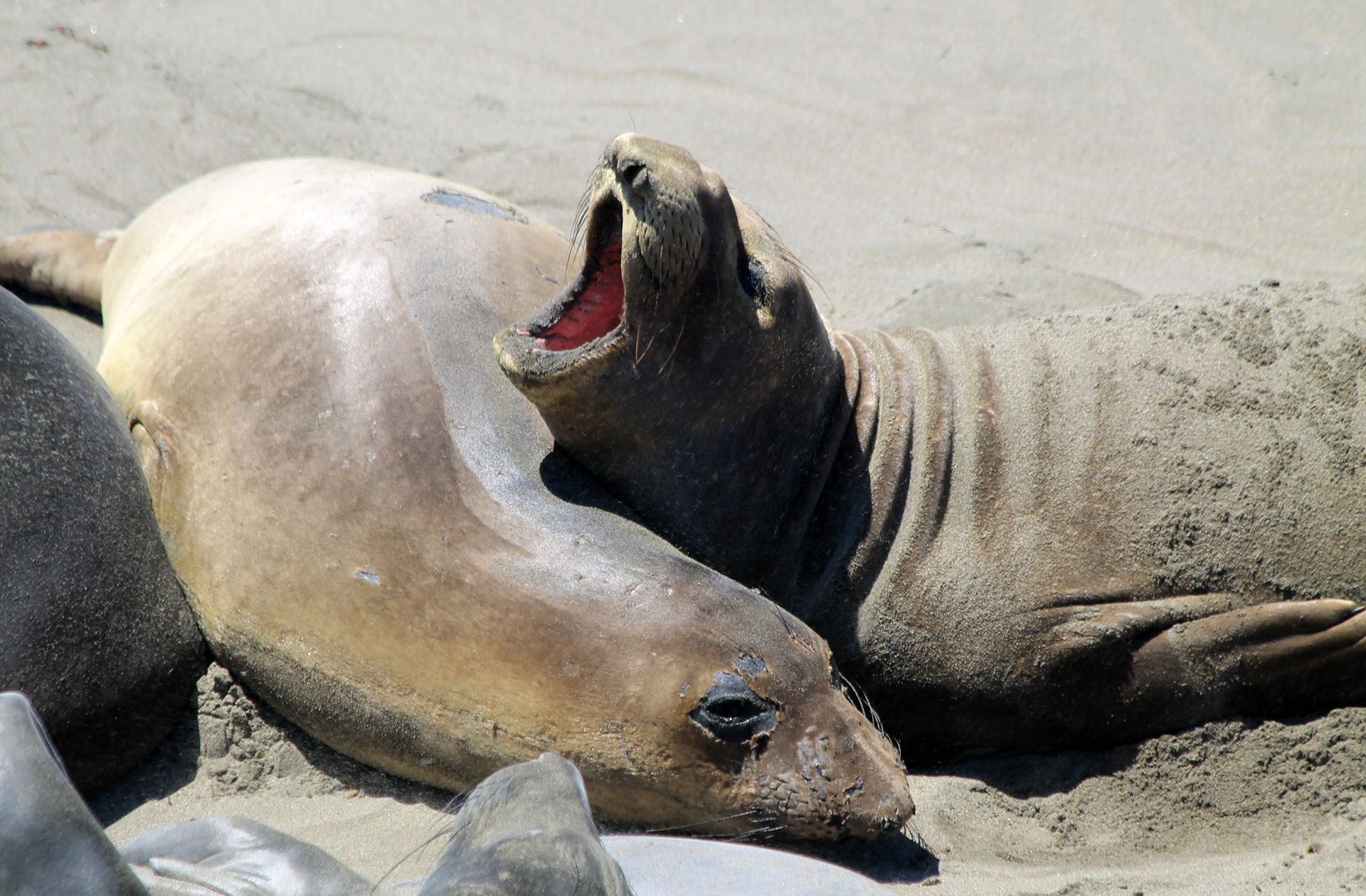 On the outskirts of the city we were amazed to see a long line of RV’s parked right on the ocean side of the road. Pretty crowded but if I had an RV I would probably stay there a day or so myself. It’s virtually a little city the way it’s set up. We pulled over and watched the sunset on the ocean one last time. We finally arrived in Santa Monica around 10 pm after a long day of driving. Our trip was finally over and I was truly sad that it was ending. I had a great experience these past two weeks and I would do it again in a heart beat but there is so much more of the country to see. If you have ever considered a trip down the coast the only thing I could suggest different is to start further up into Oregon, maybe even Washington. Oregon was by far the one of the most beautiful states I have visited to date and you won’t be disappointed with a trip there. Enjoy!!
")
")


What Others Have to Say